June 7-July 9, 2004
|
| The Sam Davis Home Slave Quarters Archaeological Project June 7-July 9, 2004
|
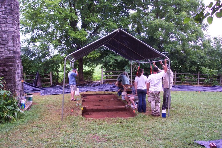
On June 7, we completed an orientation lecture from 9:00 am until noon. Our thanks to Bethany Hawkins, Executive Director of the Sam Davis Home, for a gracious welcome. After lunch, our first goal was to establish a "site grid" -- the
basic north/south and east/west system used to establish all excavation units and
mapping for the project.
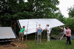
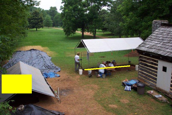
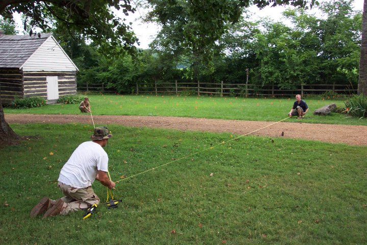
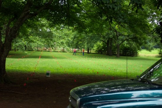
Thanks to a lovely first day for fieldwork, we were able to establish our recording grid. The first photograph below shows several of the students constructing the north-south gridline. Pin flags are placed at 2-meter intervals along this line.

After establishing the grid that will serve to orient all our finds, we began the process of learning how to set up excavation units on this grid. The next photograph below shows Mr. Chris Hogan, Project Field Assistant, instructing students in the use of trigonometry to create "square" excavation units by triangulating from the established grid.

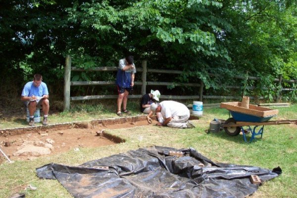
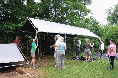
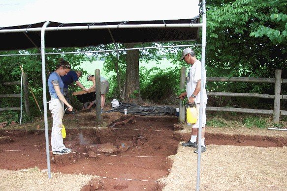
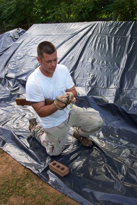
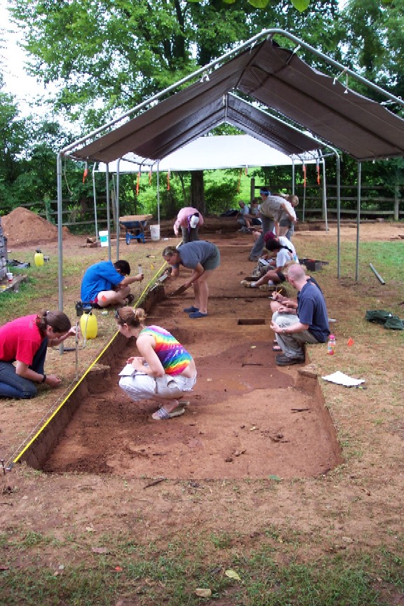
After learning how to locate the corners and place spikes, student crews learned how to string off the excavation units. We have four student crews working on the project, and were able to complete three of their units before a brief shower blew in. The final photograph of the day shows Mr. Hogan instructing students in proper techniques for setting up an excavation.

On Tuesday morning, we will lift the sod from our first four excavation areas in the search for some of the slave residences at the Sam Davis Home.
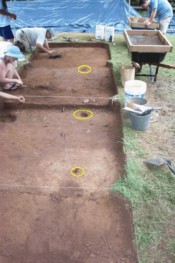
On June 8, four crews of students began excavation of four test units in a location we hope will contain the archaeological remains of a cluster or "quarter" of eight cabins. While the 1860 United States Census tells us that fourteen slave residences were located on the farm of Charles Davis -- housing fifty-one enslaved African-Americans -- the historical record does not provide many clues as to where those cabins were located.
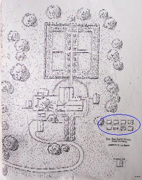
The few clues that to be found suggest that several of these residences were located somewhere to the west/southwest of the main house. The image below (Courtesy, Clyde Seale, published in History of Homes and Gardens of Tennessee 1936), is a sketch map created in 1936. Although the cabins had been gone for several years when this drawing was created and the scale is not precise, it provides at least a hint that some of the slave residences were located in this vicinity. The eight structures circled in blue are labeled "Negro Cabins" on the sketch.
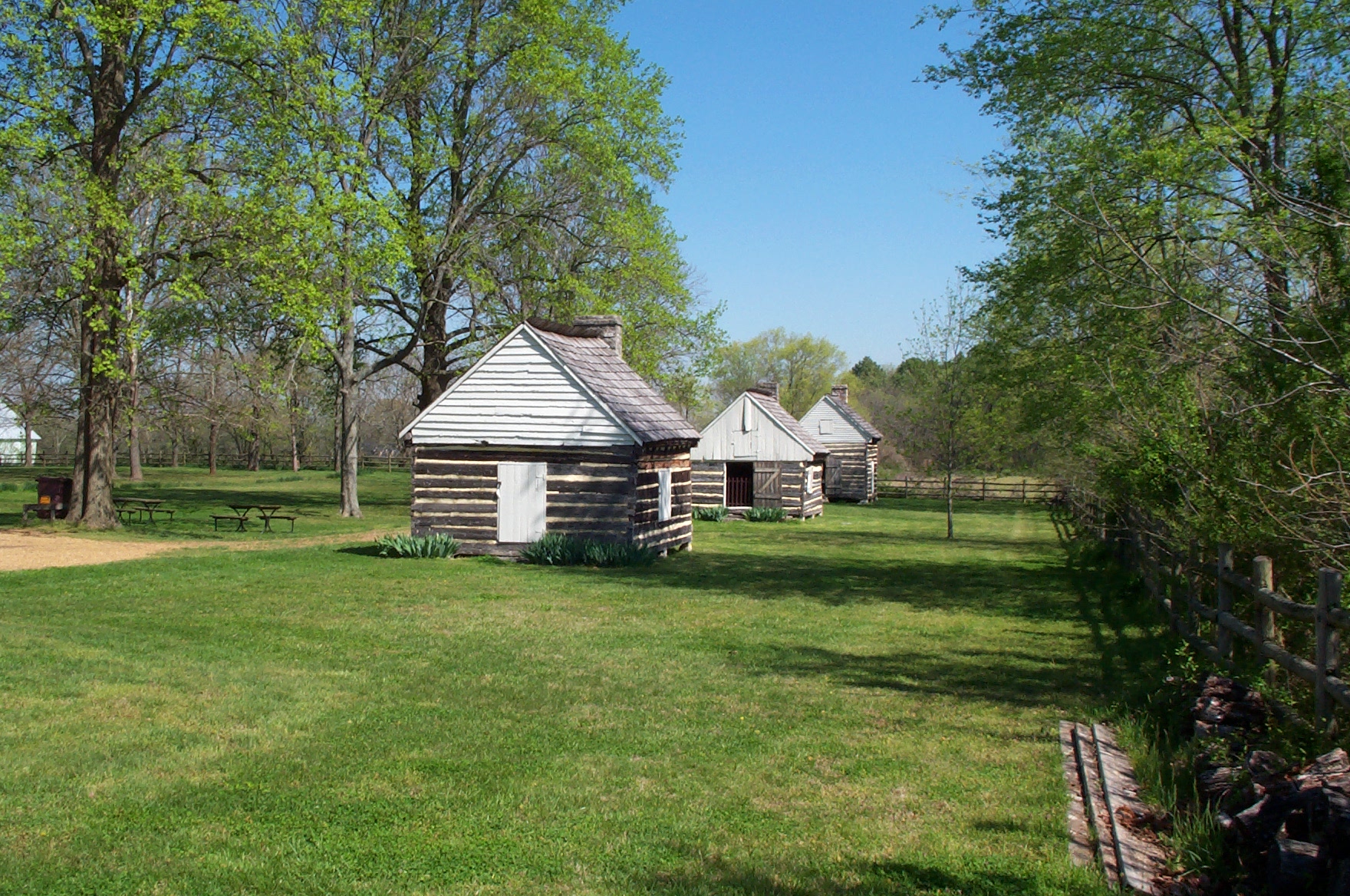
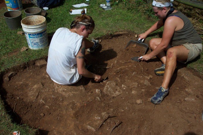
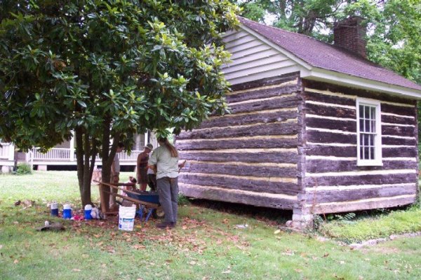
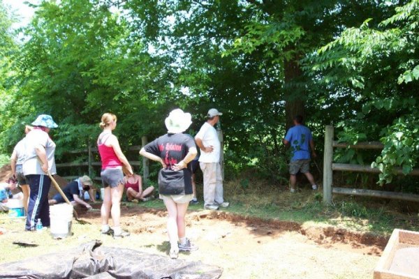
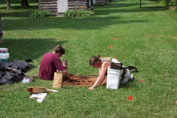
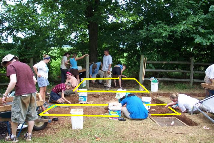
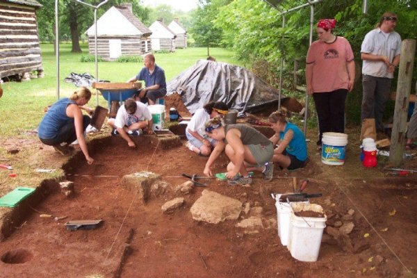
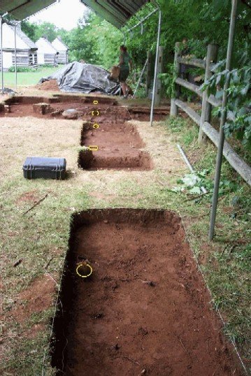
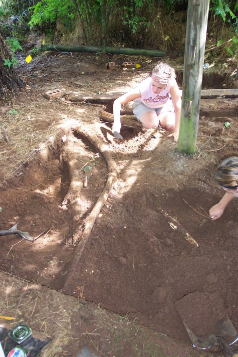
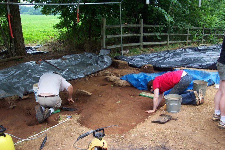
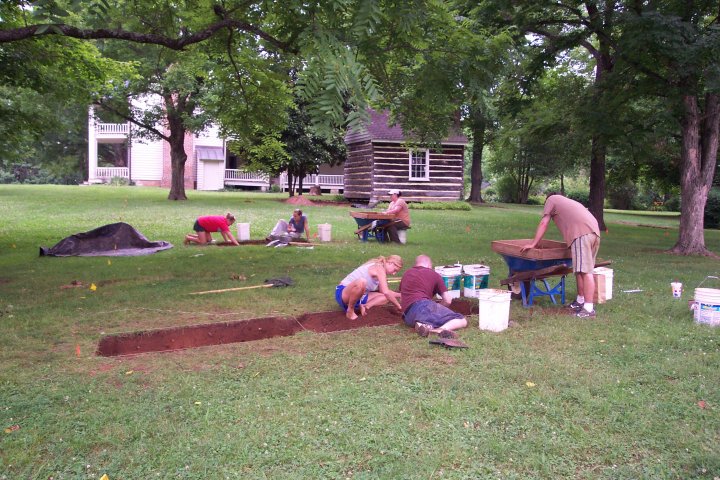
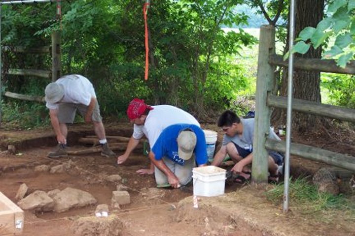
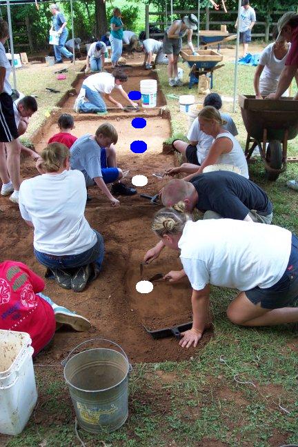
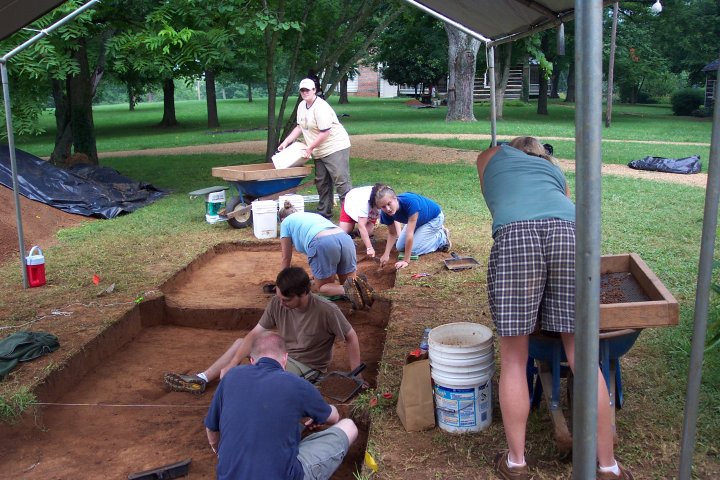
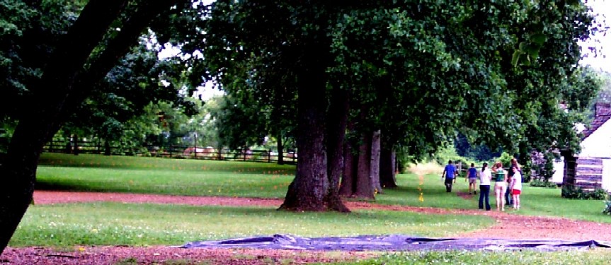
After examining the "lay of the land" to the southwest of the house, we selected what seemed to be the most likely spot for a series of residences. Each of Our four "crews" opened a one-meter square test unit to see if we can find evidence of these missing log buildings. The photograph below shows three of those crews at work -- the four log buildings in the background are slave cabins moved to the Sam Davis Home from another plantation for exhibit purposes in the 1940s.
.
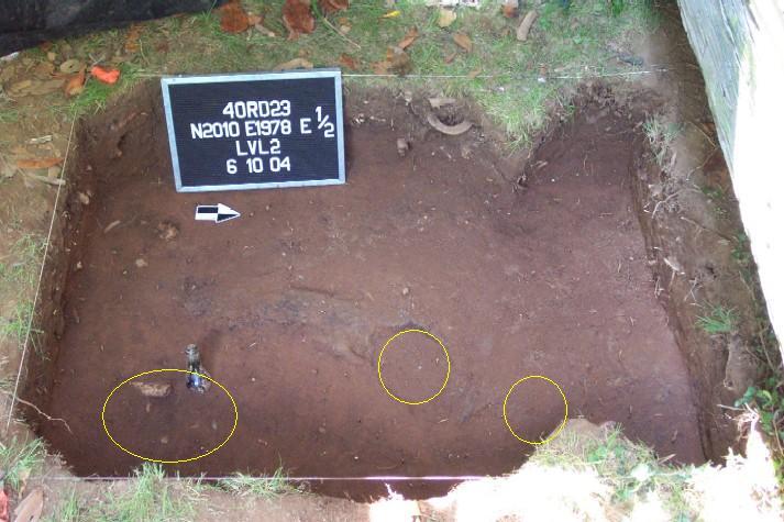
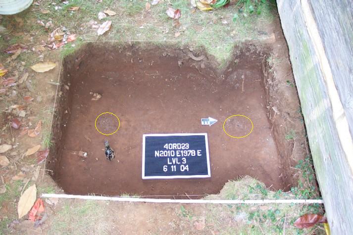
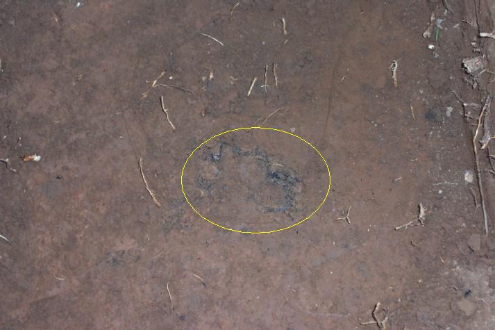
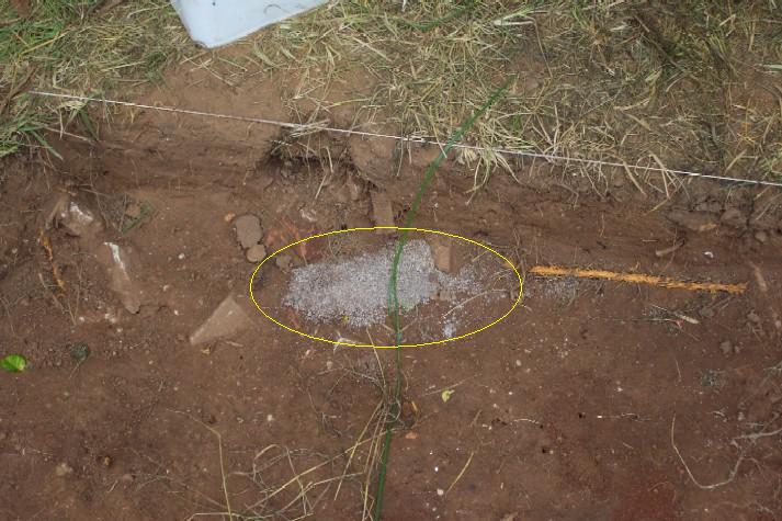
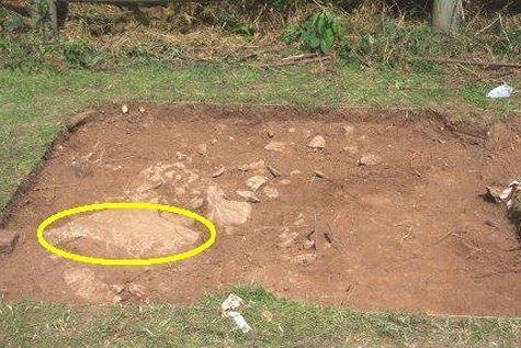
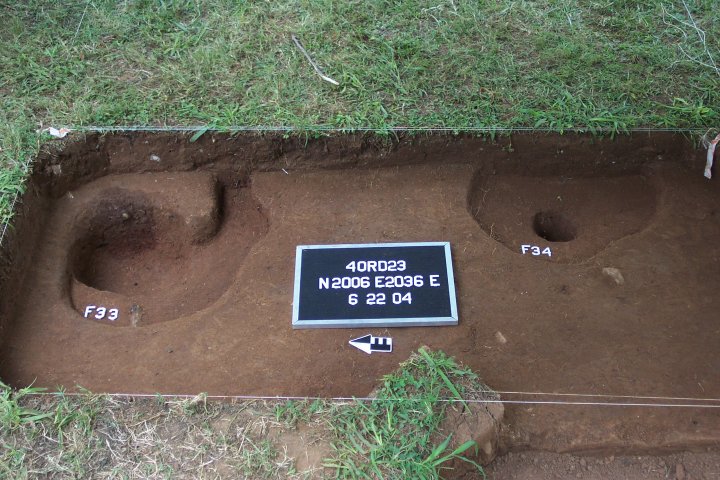
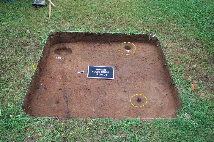
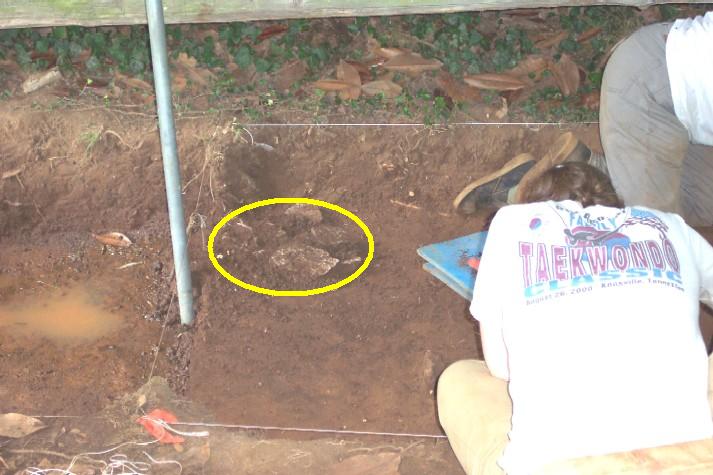
We discovered our first "feature" fairly quickly. In archaeological "jargon," features are evidence of past human activities that disturbed the soil -- things like pits, foundations, chimney bases, postholes and the like. On the left below (circled in yellow) is an orange clay circular feature surrounded by wire loops. The landscape at a place like the Sam Davis Home records the activities of the past 150 years and more -- this feature turned out to be a relatively modern feature that we were able to lift out using the wire basket (the image at right below shows students proudly exhibiting this feature after lifting it out of the ground.


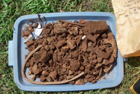
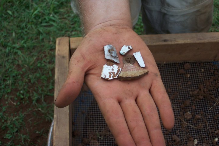
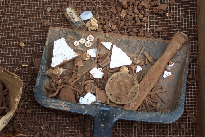
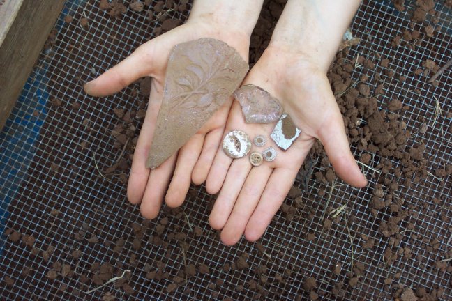
At the same time, our first day of excavations also suggests that we are in the vicinity of some residential buildings. All of the excavation units are yielding discarded objects that are likely to be near these kinds of buildings -- brick rubble, nails, kitchen ceramics, etc. The image below shows the artifacts from one bag from a single unit.

While we're finding a mix of everything from the mid-1800s through the 1900s, the deeper we go, the more artifacts we get from the mid-1800s. The "closeup" below shows fragments of ceramics, buttons, nails, a stoneware tobacco pipe, and others that could well be artifacts from our 1850-1865 slave residences.

Despite the heat, humidity and several visitations from overly friendly bugs of various kinds, we made a lot of progress for just one day in the field. At the close our first day of excavation, we took a few moments to complete notes of the day's work in our "field house" provided by the Sam Davis Home.

Stay tuned for more exciting discoveries (we hope!).
On June 9, our crews finished several test units and began new ones.
The concentration of artifacts that seems to relate to the mid-1800s is located near the modern fenceline. New excavation areas opened today continue to produce large quantities of artifacts that suggest we are in the "midst" of a domestic residential area.

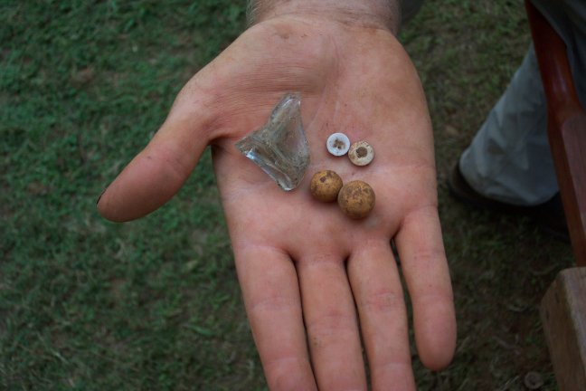
Amongst the items recovered are many fragments of stoneware "crocks"...

And, medicine bottles and "jews harps"

We have some promising indications of fencelines and buildings from today's work -- Thursday will tell whether our increasing excitement about the potential for today's finds prove fruitful!
On June 10, our students continued work on several critical excavation areas.
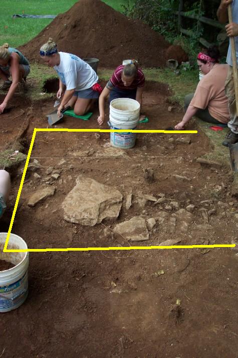
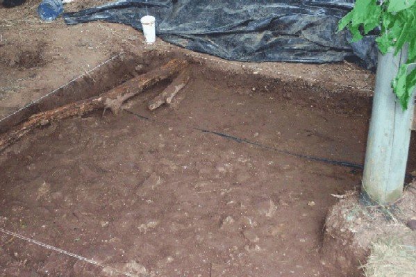
Over the course of today's work, investigations along the modern fenceline revealed clear evidence of the remains of a former building.
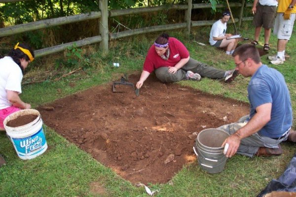
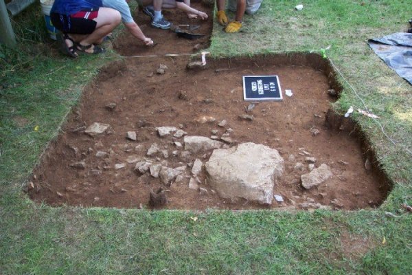
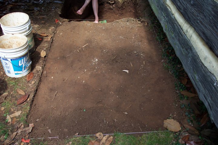
As shown in the photograph below, early in the day this excavation unit seemed little more than a "bunch of dirt."
As work progressed, however, large limestone blocks and a dense cluster of limestone construction debris began to appear...
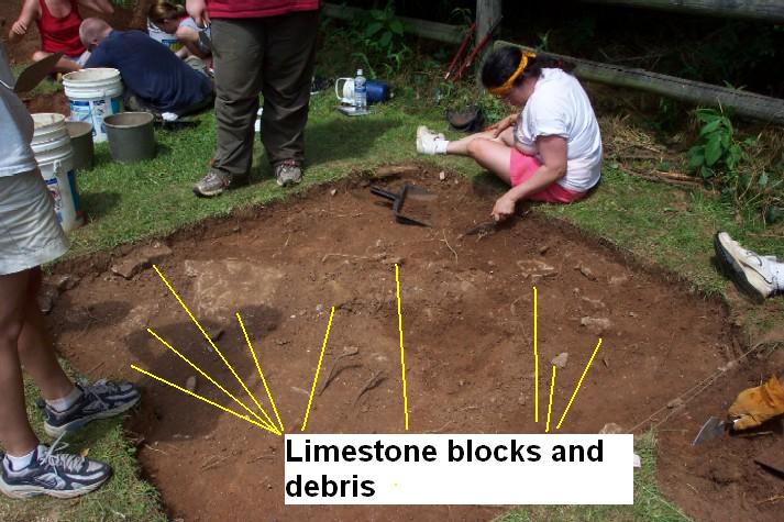
Further into the early afternoon, more and more debris from a former building had emerged as students worked to remove the dense hard-packed clay.
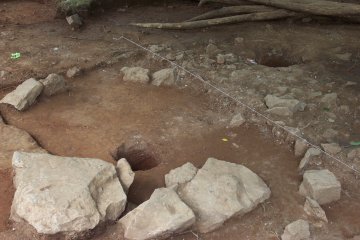
By the close of work today, a pattern had begun to emerge from the soil... The limestone blocks and debris (intermingled with brick rubble and fragments or mortar) appear to be clustered in a roughly square area that may well represent the upper disturbed portions of a former limestone chimney base. More work on Friday will be needed to test this interpretation, but we are excited by the possibilities!
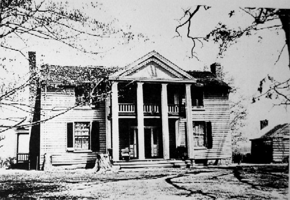
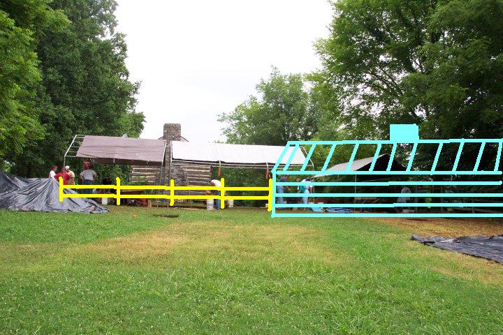
In another part of the site, students are working to locate a "lost" fenceline that once surrounded the yard of the Sam Davis Home. The current fencelines were created sometime between the 1940s and 1970s -- and don't offer an accurate picture of how the yard and other buildings were once situated. Determining where the fencelines were in the mid-1800s is critical to our understanding of the buildings we are investigating. While not very visible in this reproduction, the 1920s photograph of the Sam Davis Home shows a fenceline at the right "running" into the "office" and "overseer's residence." Other versions of this fenceline are shown in two other photographs from the early 1900s.
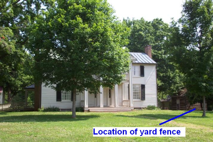
We re-created this historic photograph as shown below to get an idea of where to look for postholes from this long-lost fenceline.
On Wednesday, we started an excavation unit at this location to try to find a posthole in this fenceline.
By the close of business on Thursday, we were almost 40 centimeters (15 inches) deep. Despite some heavy disturbance from the roots of the nearby magnolia tree, we have found at least three possible postholes (marked in yellow in the photograph below). Given that the historic photographs show at least three versions of this "yard fence," we expected a rather complicated pattern of different fenceposts and fencelines. We'll begin to investigate these possible postholes on Friday. Hopefully, by the end of our field season, we will be able to establish where this fence began, and identify the location of gates leading from the yard to the slave quarter.
Given how little we knew only three days ago about "possible locations" for some of the slave residences, we have made some tremendous progress in narrowing our search area. Archaeology is slow and tedious work -- but has already begun to provide many new clues about the past buildings, landscape, and peoples of the Sam Davis Home.
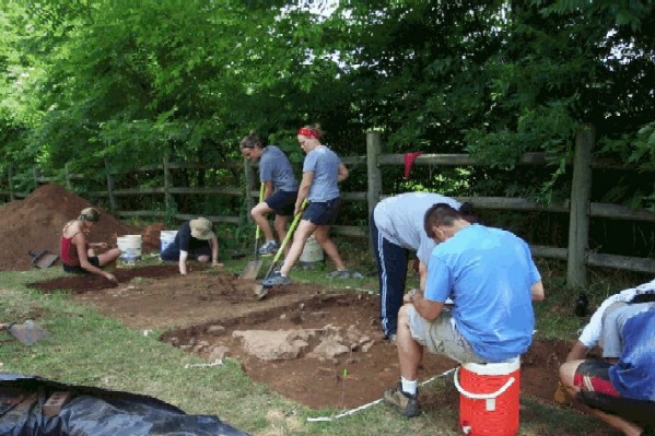
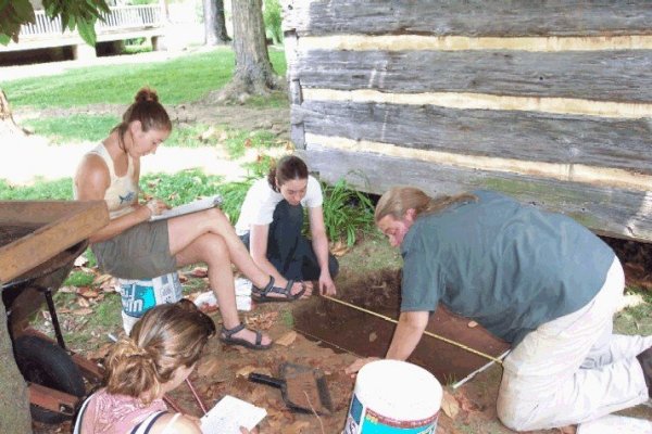
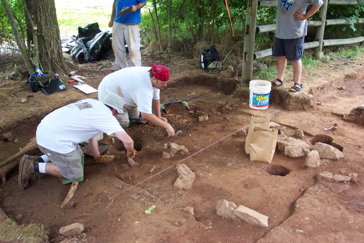
Thanks to the hard labor of our student crew over the past four very warmish days, we close out the first week of class with several exciting discoveries. During the course of today's work, we cleaned up the cluster of limestone blocks and chipping debris reported yesterday.
Some cautious probing around the exposed stones suggests that as we excavate deeper, this cluster of "rocks' will be more clearly define. However, before we do further work on this portion of the possible chimney base, we need to expose the entire feature so that we can work on it as a "whole." So, after cleaning it up at this depth below the surface, we opened the excavation unit to the north. The photo below shows Lesley and Amanda clearing the sod on the unit to the north, while Mackenzie and Chris work on mapping the exposed stones.
Since we now believe that the building we are investigating extends beneath and across the modern fenceline, we removed the rails from two sections of the fence in preparation for future excavations. That preparation also included cutting brush and carefully digging out several patches of poison ivy.
In addition to the building from the 1800s we are investigating, we have also found several more recent "features" in our excavations. Four posts from an older version of the modern fenceline have been identified -- with a slightly closer post spacing.
Relatively well preserved remnants of these wooden posts are present in all of the postholes...
We suspect these are the remains of the board fence that was present on the property in 1975, when the first archaeological project was conducted at the Sam Davis Home. The photograph below (Courtesy, Nick Fielder, Tennessee Division of Archaeology) shows this board fence and some of the 1975 excavation units to the south of where we are currently working.
Since we have some indications that there are two rows of cabins running east-west in this location, we also started expanding our test excavations to the north of our current building location. As the project proceeds next week, we will begin to report on the results of the search for additional structures there.
In another part of the Sam Davis property, our search for the original "yard fence" continued today as well, with good results. Tiffany, Meagan, Ryan, and Lauren continued excavations...
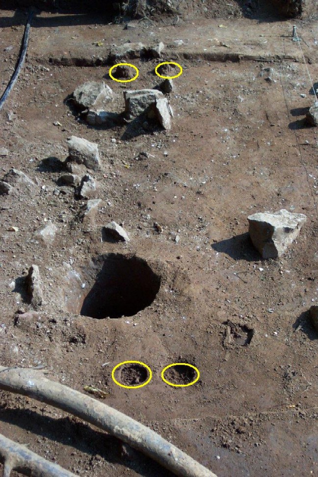
Our original three "possible postholes" reported yesterday didn't pan out with further investigation, but with a bit more digging today, we did find two "definite" postholes in a line extending from the "overseer's house" to the south.
One of these postholes still contains remnants of a post from that fence (shown below). In the other, the post was apparently removed when the fence was dismantled and the posthole was packed with debris.
As I close off for today, a reminder to our readers that archaeology is not just about "digging up artifacts" and "finding cool stuff" -- while that is an important part of our work, the students involved in this project are also learning the additional important parts of "archaeology." When we finish exposing clusters of rocks and possible postholes, we pause and draw "maps" showing the precise locations of all of these things, we clean up the excavations and take formal record photographs to document our work, and we keep careful records each day of what happens. That part of the work is tedious, boring, and repetitive -- but it is what allows us to interpret and understand what we are finding.
Visit us again next week as the work continues!
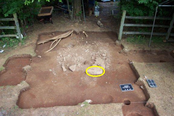
A brief report for today... Work continued on what we are now referring to as "Structure 1." The likely chimney and hearth base continues to become better defined as we dig deeper. The photograph below shows the "feature" outlined in yellow -- if you look closely, you'll see that the concentration of limestone blocks, chipping debris, and brick rubble has begun to form a square or rectangular pattern. Tracy, Amanda, Leslie and Cheryl continue to carefully clear around the exposed rubble.
As noted on Friday, before we continue deeper investigations of this feature, we need to expose the top of all of it. As a result, we opened three additional excavation areas (outlined in yellow in the photographs below).
Our efforts are both helped and hindered by "Mother Nature" -- when we arrived this morning, the plastic covering our excavation units was filled with several hundreds of gallons of water from the weekend storms. Our first 45 minutes of the day were spent "bailing water" before we could remove the protective plastic. A friendly but fairly frightened mouse who had established a new home underneath our plastic during the weekend was forced to relocate. Of some interest are the results of the labors of the several dozen ant colonies that inhabit our excavation units. While we are not particularly thrilled about trowelling through an anthill and suddenly finding ourselves covered with multitudes of the little critters, the photograph below shows what many of these diligent workers are telling us about what lies beneath the soil. The grayish-white anthill outlined in the photograph is a mixture of ash and mortar brought up from two-three inches beneath our current excavation level. As we excavate deeper, we anticipate getting into less disturbed features of the site -- the ants are providing additional evidence to support our hopes!
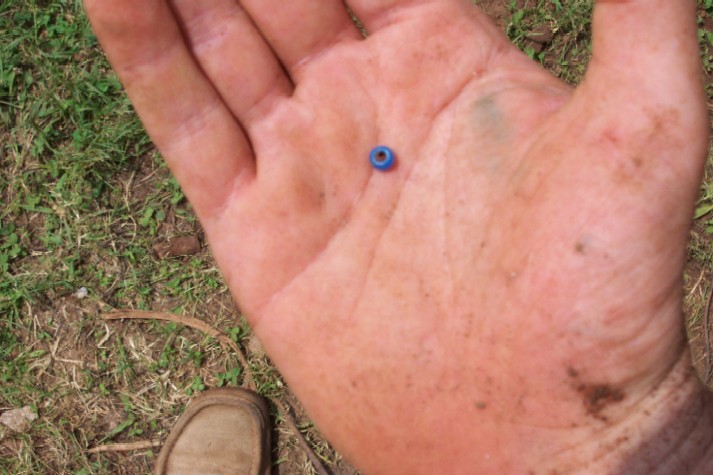
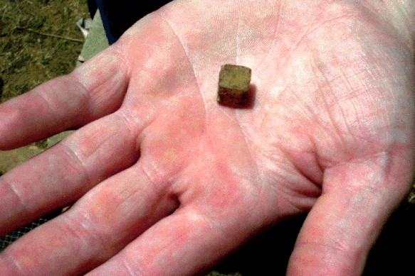
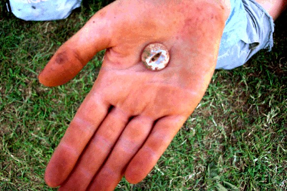
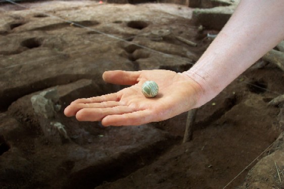
Amongst the several hundred artifacts recovered today was one of particular interest to us. Our first bead. While perhaps coincidental, it is of interest that it is a "blue bead." From work throughout the south on slave sites, we know that African-Americans of the 19th century exhibited a preference for blue beads over other colors -- a preference that extends back to West African ancestors. While one blue bead does not a slave cabin make, it is another tantalizing hint that we are in the right place on the landscape of the Sam Davis Home.
After class on Tuesday, I have a meeting in Nashville and won't get home until 9:30 or 10:00 pm, so anticipate a very brief update for tomorrow's work! A full update will be provided on Wednesday on the next two days of work!
Another brief report for today -- your daily reporter was at work in the field from 7:30 am until 5:00 pm and then at a meeting in Nashville until after 9:00 pm. A full report will be posted on Wednseday evening!
Work continued today on the part of several of our crews to further investigate the chimney base...
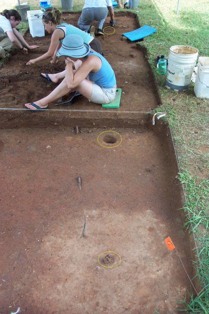
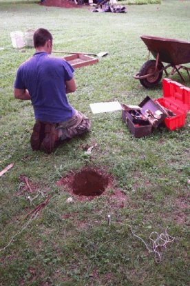
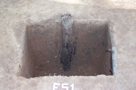
Other students worked on examining some of the many postholes and posts we have discovered. The photograph below shows Lacey and Pat excavating a posthole with ancient cedar post remnant still in place. Unlike some of the postholes mentioned in prior updates, this one appears to date to the 1850s.
As it now nears midnight and I must be up and away at the break of dawn, I'll close off for tonight. Check back tomorrow!
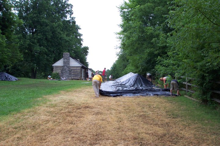
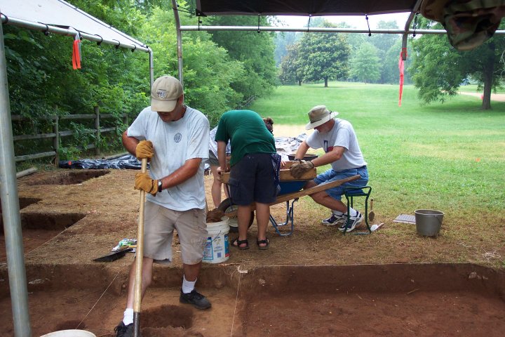
We have made a tremendous amount of progress in our first seven days of fieldwork. To protect the fragile archaeological remains from possible storms, we cover the excavations with plastic at the end of each day. The first thirty minutes of each day is spent removing the plastic, setting up the shelters, and gathering equipment.
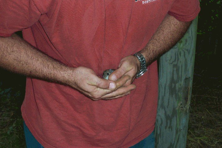
Fortunately or not, each evening our excavation units are "colonized" by a variety of critters. Yesterday, two mice had built homes in our excavations -- this morning, three had established temporary residency. Below, field assistant Chris Hogan assists one of squatters in a relocation to another part of the property.
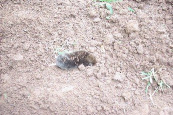
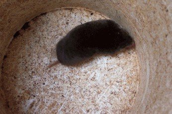
Later in the day, we startled another resident of the Sam Davis property by digging him up -- the photo to the left below shows a large and healthy mole in rapid motion; the photo to the right shows him in a bucket being transported to another location on the property.
Every day is a new adventure in "wildlife recognition."
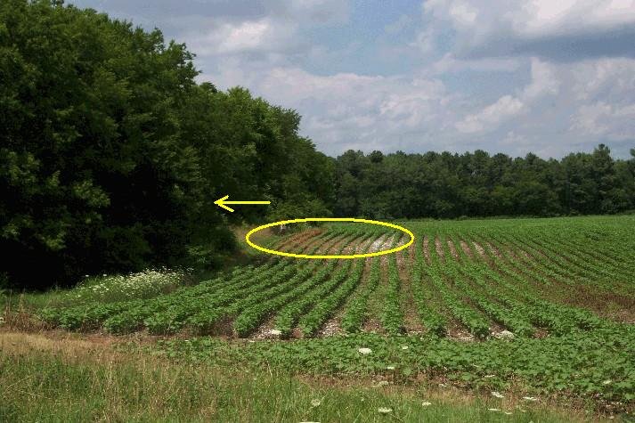
But, let's get to "archaeology." As students continued to work on excavation units, Chris Hogan and I conducted a survey in the cotton field east of our current work area to try to establish the extent of the archaeological deposits. Using a metal detector, we systematically flagged the "hits" (while carefully avoiding damage to the young cotton plants). The photo below shows a section of the flags between the cotton rows -- our current Structure 1 is outlined in yellow in the background to the west.
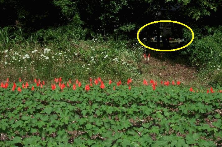
We aren't diggng up artifacts in this process -- we are using the metal detector to establish densities of metal objects (mostly nails) to help locate where our suspected two rows of four cabins are located. The photo below (looking north) shows the area of greatest artifact density in the yellow oval -- easily large enough to hold two rows of four cabins. The yellow arrow points towards our current excavation area across the treeline.
Excavations also continued on the chimney/hearth base of Structure 1. As shown in the photograph below, the square feature is becoming more clearly defined and outlined as we excavate deeper. After this photo was taken, we began excavation of the unit containing the fourth corner of this square -- hopefully, we will have the entire feature exposed by Thursday afternoon.
During the course of excavations, we also discovered another "modern feature" of the Sam Davis Home -- an abandoned water line for a sprinkler system. Installation of this system a couple or three decades ago had disturbed and destroyed part of Structure 1 -- underlining the great care and caution that must be used when disturbing the landscape of any historic home. Hopefully, our work will provide the Sam Davis Home with additional information about areas that should be avoided in future planned projects.
This afternoon, we also opened several new excavation units to the south -- in a search for the second row of cabins. While the early results are promising, our first discoveries continue to confirm the ca. 1970s fenceline that parallels the modern fence. The posts we have found so far are outlined in yellow.
At the close of each day, we also have to "spray down" many of the excavation units. During the day, our excavation areas dry out -- making it difficult to see postholes and other features. Spraying them down with water before covering them with plastic for the night help to "re-hydrate" the soils for examination and excavation in the morning.
As we continue to expand our excavations -- we also continue to expand our understanding of the many activities that have taken place in this part of the Sam Davis Home landscape over the 150+ years. As a result, we are increasingly able to sort out 1980s waterlines and 1970s fencelines from postholes and features that were created in the 1850s. We have to be able to sort the older from the newer before excavating deeper -- we now begin to think we have a good "feel" for which of the features we are discovering belong to the older residences for which we search. As our understanding expands, the pace of our discoveries will also increase. We have broken "new ground" and started to understand it -- now we will proceed with finding the "old ground" and learn to understand it as well.
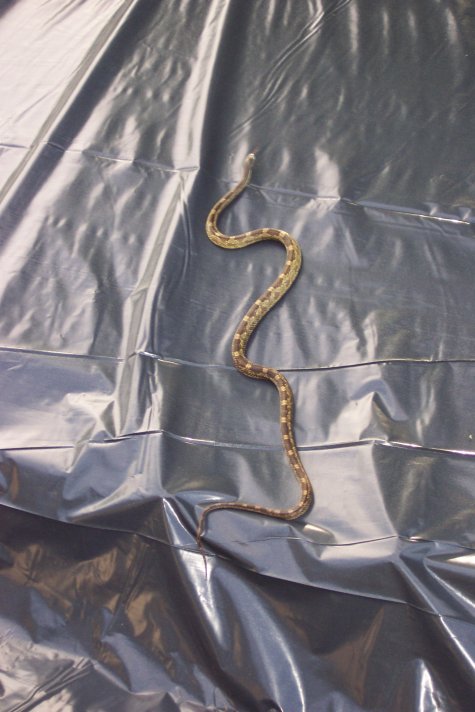
The daily "Wildlife lessons" continue... Apparently having seen the many mentions of mice in our webpages, a very interested local resident showed up this morning to tour the "digs." Following our safety protocols, students vacated the area while trained staff member Chris removed the large but non-poisonous visitor. He/she was relocated to another part of the property. While we are unable to confirm or deny any relationship -- only one mouse was located under our plastic today.
Exposure of our "big feature" continued today -- despite rain that started about 11:30 and lasted until after 2:00 pm. We made significant progress on exposing the fourth corner of this feature -- despite some massive tree roots intruding into the excavation area.
We continue to find large quantities of artifacts in each excavation area...
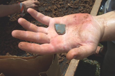
Including many fragments of slate writing tablets like the one shown below...
We were slowed a bit by the rain today, but hope to have the center of Structure 1 exposed early on Friday morning -- and begin investigating its mysteries. Check back on Friday evening for some new discoveries!
At the close of our second week, we have excavated almost 500 cubic feet of dirt -- about six small truck loads. Compared to what you can do with a backhoe, it doesn't sound like much. But when you consider that every bucket was carefully hand excavated and all of the dirt processed through screens to recover artifacts -- it is an amazing amount of work in only nine short days.
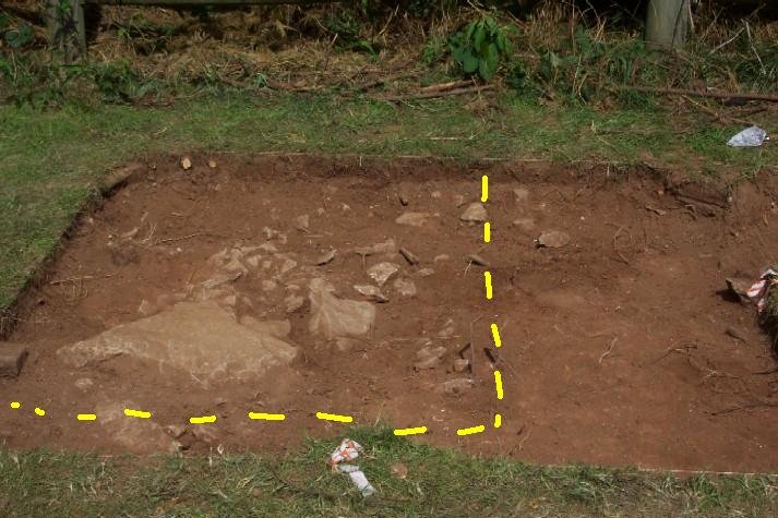
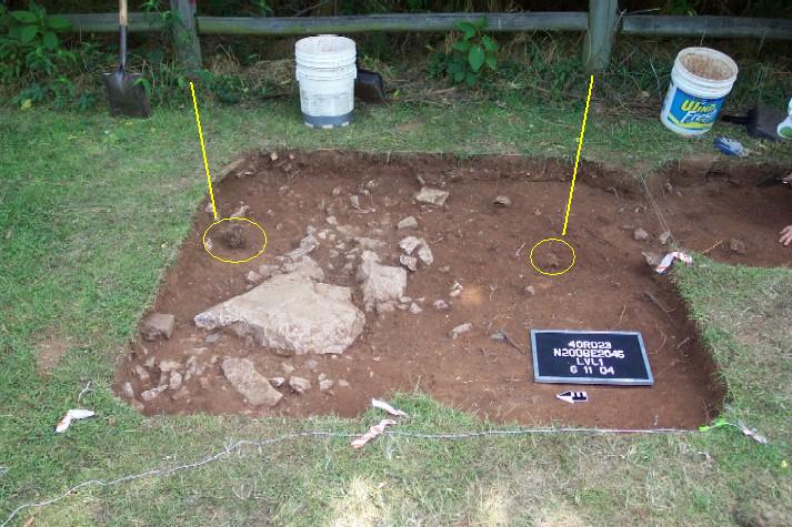
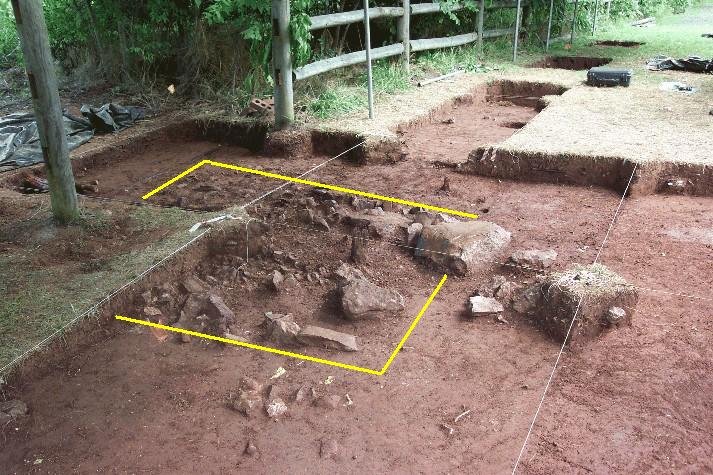
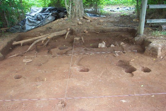
A large part of our efforts today focused on cleaning up the units in and around Structure 1 -- including the large feature believed to be a chimney base, cellar, or both. We managed to fully expose this feature today -- now affectionately known in archaeological jargon as "Feature 14." A large part of archaeological research is about patience. We exposed the first small part of Feature 14 over a week ago in one of our excavation units. Once we identified it as something "probably significant," we stopped digging deeper in that area. We stopped because we needed to see the full outline of it before we begin to dig deeper into it. Why? Looking at the "whole thing" tells us how to treat the feature in our future excavations -- how big is it? What is it likely to be (given our knowledge of similar features from other sites)? Unless we can see "the whole thing," we don't know how to plan our investigations of it.
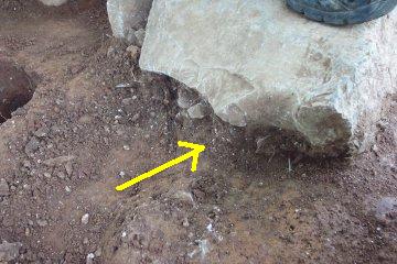
The photo below shows the first section of this feature, as photographed on June 10. Keep in mind the large limestone block circled in yellow...
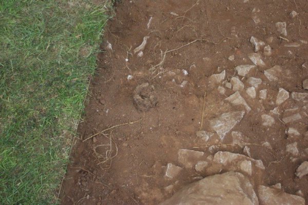
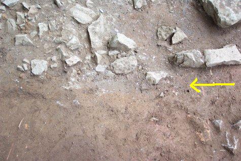
As we worked throughout the day today, we carefully cleaned and examined all of the excavation units to define the outlines of the whole feature... We look for subtle (and sometimes not so subtle) differences in soil color and texture to define the outlines of "things from the past." The photo below shows the edge of Feature 14 in "closeup." Note the clear and distinct break between the orange-brown clay below the "yellow arrow" and the dense cluster of limestone mixed with mortar, plaster, and other items above the arrow.
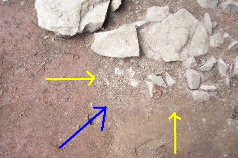
The photograph below shows more of the same -- only this time a "squared corner" of Feature 14. The "yellow arrows" point to the edges of the feature -- the blue arrow points to the sharp corner.
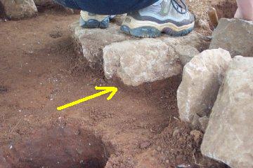
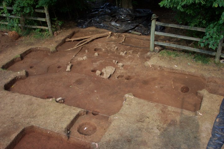
The photo below (taken from about 14 feet above the ground on a very sturdy ladder!), shows the whole feature as exposed and mapped at the end of work today. The yellow circle is the same limestone block shown in the photo above from June 10 -- a big change in how we look at this feature from "way back then!"
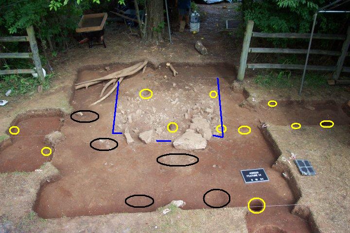
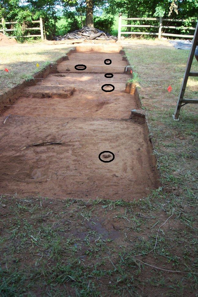
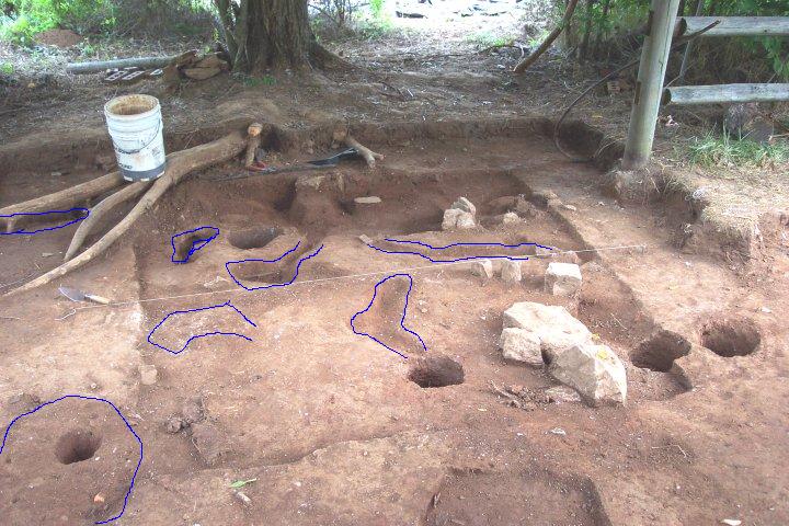
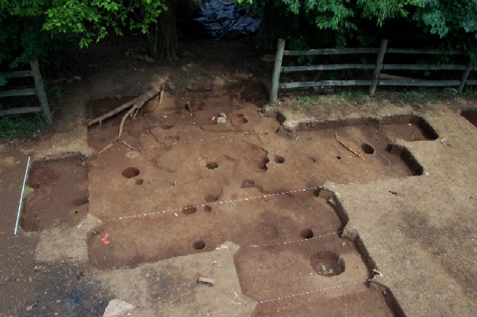
Our investigations have revealed nearly 20 "features" in this single excavation area -- they are highlighted below. Feature 14 is outlined in blue. This square or rectangular feature is our chimney base or cellar fully exposed. The yellow circles are postholes that range in age from probably about 1850 up through the 1980s. The black ovals/circles show possible shallow pits or other features that remain to be better defined. Now that we have identified, defined, mapped and photographed all of these potentially significant features -- we will begin to delve deeper into them next week.
We now have only three weeks left in our five week project. For the project, we have already in two brief weeks moved from "let's try to find the slave cabins" to "we're pretty sure we've found some of them." For the students, they have moved from "I have no clue what I'm doing" to "I'm starting to understand how to do this."
More news to come next week...
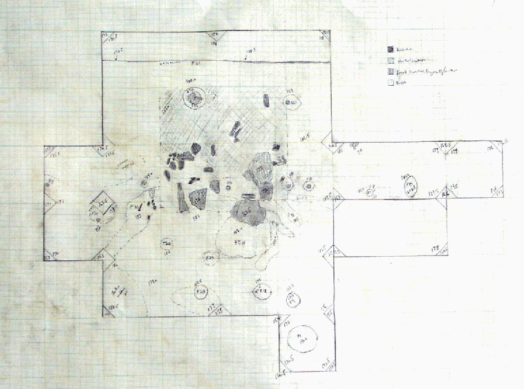
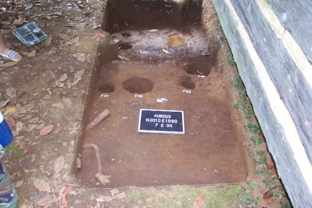
The beginning of our third week brings both good news and bad news. Work continued for the entire morning on cleaning and mapping the units in and around Structure 1. Other crews finished excavation units and opened new ones. Below is the "map" or "plan view" of the Structure 1 area.
Before proceeding with excavation, we have to carefully record all of the information in both photographs -- and drawings. Many of the "features" that we can see "close up and personal" do not show up well in photographs. In fact, some of the features are not so much "seen" as "felt" -- dirt that is precisely the same "color" may "feel" different with the trowel because it is looser, or harder, or contains tiny fragments of brick or mortar. Teasing an understanding of the many things that have happened in and around our "chimney base" over the past 150+ years is something both of science and of art.
After further cleaning and mapping of the area, our interpretation of various features changed from Friday... The first photograph below shows our interpretation from Friday...
The photo below shows our changing interpretation as we begin to investigate these features more thoroughly... The light blue circles show newly defined probable postholes. The areas outlined in red are what we think are old burrows from various sized rodents -- mice, rats, groundhogs, 'possums, etc.
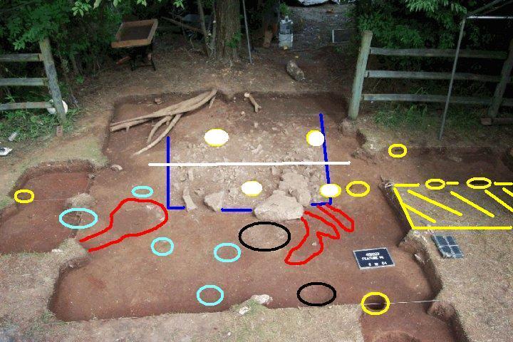
In addition to photography and mapping, before beginning excavation of the "chimney base," we had to excavate several other "features." In the photo above, the "white filled circles" represent postholes that are intrusive into the chimney base. In simple terms, these are postholes that were dug after the chimney was gone and "intruded" into that feature. While perhaps difficult to explain on a web page, we try to excavate overlapping features in "reverse order" of the time they were created. We can tell that these postholes were dug after the chimney base -- so we take them out first. This allows us to segregate the "newer artifacts" that might be in the "newer postholes" from the "older artifacts" that are in the undisturbed parts of the chimney base. We excavated the intrusive postholes today -- and began a "cross-section" of the chimney base -- the area below the white line crosscutting the chimney base feature (outlined in blue).
As we continued through the day, we also opened another excavation unit -- shown in the photo above in cross-hatched yellow lines at the right. In order to interpret the multiple postholes that we have in this area, we need to see a slightly larger area.
We will spend several more days figuring out what precisely is going on in this area. Each posthole has to be examined carefully for size, location, contents, and other information. Based on what we have figured out up through today, we can interpret several of the postholes we have found. The image below shows the existing fenceline (with the post and rails we removed in yellow) -- and an older version of this same fenceline simulated in black-filled postholes, posts, and planks. Each of the posts show in "black" contains the same kind of post, similar diameter, similar depth, and similar spacing. So, we can explain those postholes. The others we have investigated so far contain different kinds of posts, different sizes, and/or spacings that don't match that fenceline. So, we will continue to investigate each of these postholes -- carefully recording their size, contents, depths, and spacing -- in order to figure out "which ones seem to go together."

Although we're not positive, we think the old fenceline "reconstructed" in the photo above may well be the remains of the plank fence in the 1975 photo below...
Beyond our investigations around Structure 1, we expanded our excavations in several different areas to gain a better understanding of the distribution of artifacts and possible other structure locations. To the north of our current excavations, we continue to look for evidence of a possible "second row" of structures -- we opened new excavations there this morning.
To the west of Structure 1, we also opened a new excavation today -- the size of the chimney base suggests that it might be a "central chimney" with a room both to the west and east. Fairly quickly, students found an ash and mortar filled feature (see the "white stuff" in the excavation).
Other students continued work on the edge of the cotton field -- searching for additional evidence of cabins...
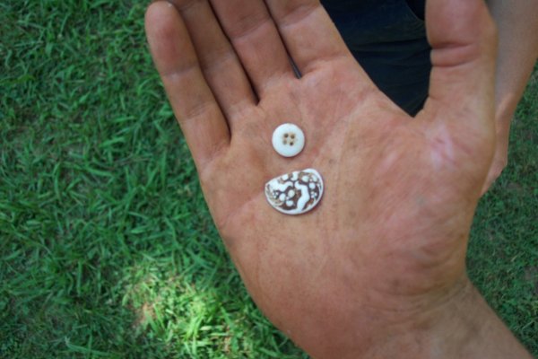
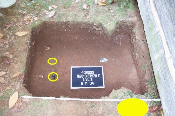
As we started investigating the chimney base, we found several white glass buttons -- two of those are shown below (including a fancy one)...
Saving the "bad news" for last... much of the area that we need to investigate further is in the treeline and cotton field just outside the current fenceline. While we have several more things to investigate in our current and new excavation units -- we will have to step back and re-evaluate what we can do effectively over our remaining few days. More news on Tuesday evening....
As we settle into our "routine," each day begins with uncovering the excavation areas. Two weeks ago, that task took about 30-40 minutes to complete -- today, we are down to about 10-15 minutes...
Work continued on "Feature 14" -- our chimney base or cellar. As investigation continued today, we discovered that it is a very shallow square or rectangular feature -- probably the remnants of a chimney base for a large chimney.
As we excavate, we pay careful attention to what is under the large stones. The photo at left shows a large stone with "rubble and mortar" underneath it that we believe represents the "destruction" of the chimney. In other words, this stone was moved here after the chimney was destroyed. The photo at right shows another large stone with "clean" clay underneath it. In other words, this stone might still be in its original position. So, Left Stone gets removed and Right Stone remains in place for further mapping.
More discoveries of the day from the Structure 1 area continue to convince us that we have found a structure that people lived in... The photo below shows one of a pair of dice found today in the chimney base area (like you use to play Monopoly with!).
And we continue to find many buttons -- this is a nice shell button.
Work continues on Wednesday...
Today, excavations continued on the multitude of features in and around Structure 1. Several postholes and "rodent burrows" were excavated by Pat, Lacey, John, and Meagan...
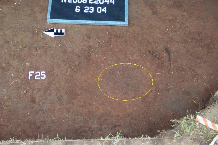
The faint dark stain shown in the photo below labeled as "Feature 25" was a suspected posthole...
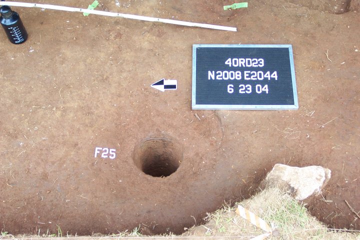
And, as we suspected, it turned out to be another deep posthole as shown in the photograph below after excavation...
As the slow work continues around Structure 1, other student crews are expanding our investigations in other parts of the Sam Davis property.
Ryan, Tiffany, Meagan, and Lauren continue to work just west of Structure 1 in an area that we think may be beneath where Structure 1 once stood... They investigated several rodent burrows -- and found another posthole.
Two crews are now working in the east yard area. They are finding some promising artifacts -- including large partial bricks and other artifacts that suggest we are possibly in the vicinity of yet another unrecorded building... In the background Amanda, Lesley and Mackenzie are starting a new excavation unit and in the foreground, Tracy, Michael, and Andy are starting their second excavation unit.
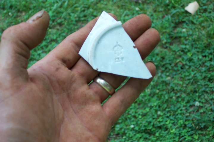
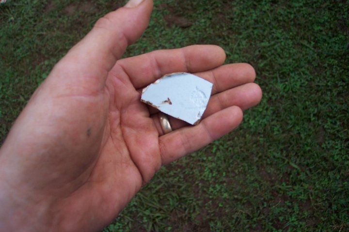
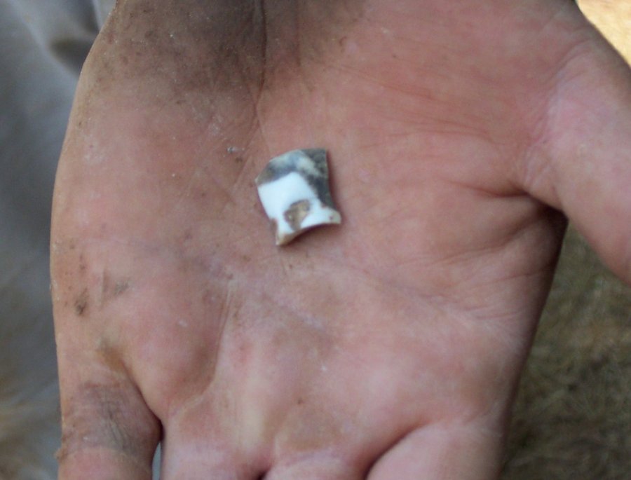
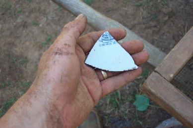
The partial plate fragment shown below was discovered in the east yard area today -- it has a "maker's mark" on the back that we hope will provide a fairly tight date for this piece of pottery.
.
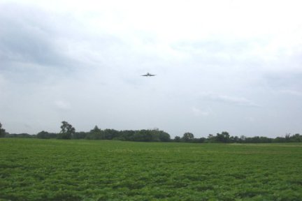
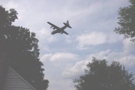
While parts of our day are quiet and interrupted only by our own noise, we are often reminded of the proximity of the present -- and the airport.
Today ended much as they always do as our routine settles in -- carefully covering our excavations to protect fragile clues of the past at the Sam Davis Home from the elements.
Archaeology is hard work -- the heat, humidity, threat of storms, chiggers, ticks, sweat bees, dirt, sweat, and just simply the tedium of digging are not at the top of the list of "our favorite things." What makes this all worth the effort? As James Deetz wrote -- the "Small Things Forgotten" is a part of what makes this worthwile. Discovering a button lost a century or more ago -- wondering who last touched it; discovering a fragment of plate, cup, or saucer -- wondering who broke it and how; discovering a posthole -- wondering who dug it and when and why... All of those things provide some part of why archaeology captures our imagination -- despite the hard work. And, ultimately, for many of us -- it is about a search for answers to larger questions. The reminder at the end of the day as we contemplate "the big picture" -- while our search is for some lost cabins that once housed enslaved African-Americans at the farm of Charles Davis, we hope our results contribute to something larger. The African Diaspora dispersed millions of Africans and their descendants throughout the globe. Slavery, the Civil War, and their legacy continue to affect us today. Archaeology is not just about the ancient past -- it is another way to understand how we came to be where we are today and to try to understand where we are going.
Join us again on Thursday for another update on our work...
Most of our work today focused on finishing some on-going excavation units and starting some new ones... Early this morning, one of our excavation units in the area of our slave cabin looked like this... (note the two postholes outlined in yellow)...
By this afternoon, we had opened two additional 2-meter-square excavations units -- and identified yet another fenceline. The two yellow circles at the bottom of the photo are the same as shown above. This fenceline appears to be older -- and consists of cedar posts driven directly into the ground.
The photo below illustrates the location of this "new" fenceline -- the yellow rectangle shows the approximate location of the "chimney base." Work on Friday will hopefully confirm our hypothesis that this fenceline may be related to the "yard area" of Structure 1.
These two new excavation units also continue to yield large quantities of artifacts. Some of these shown below continue to convince us that we are working in an area where a slave cabin once stood (fragments of pottery, buttons, etc.)
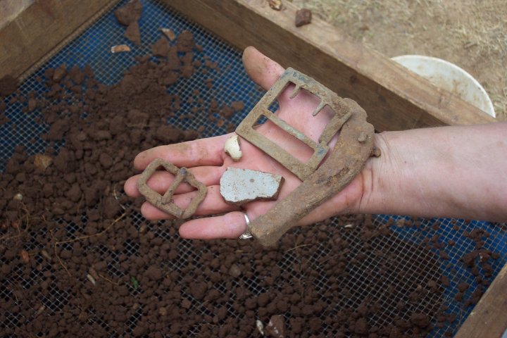
But, we're also still getting a "mixed bag" of artifacts like those shown below -- including a lot of "farm related" equipment such as harness buckles, horseshoes, but also a broken marble and fragments of stoneware "crocks."
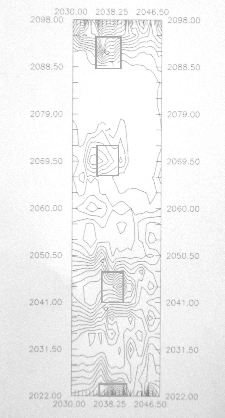
Another major project we started yesterday and continued today is a systematic metal dectector survey of the yard area. As the photograph below shows, we are gridding off the yard area in 2-meter-squares. We then systematically record the number of "hits" on a metal detector. We're not "digging" to see what these artifacts are -- just recording the "bleeps/square." This information is being plotted daily using computer software to generate information about the "density" of metal artifacts...
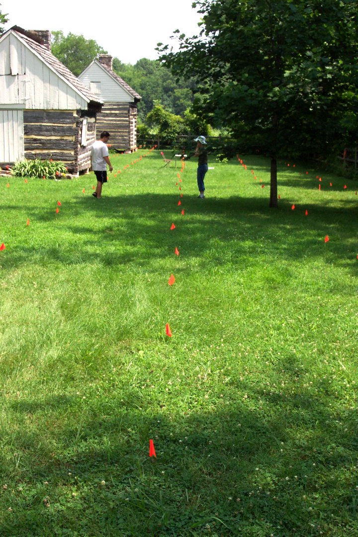
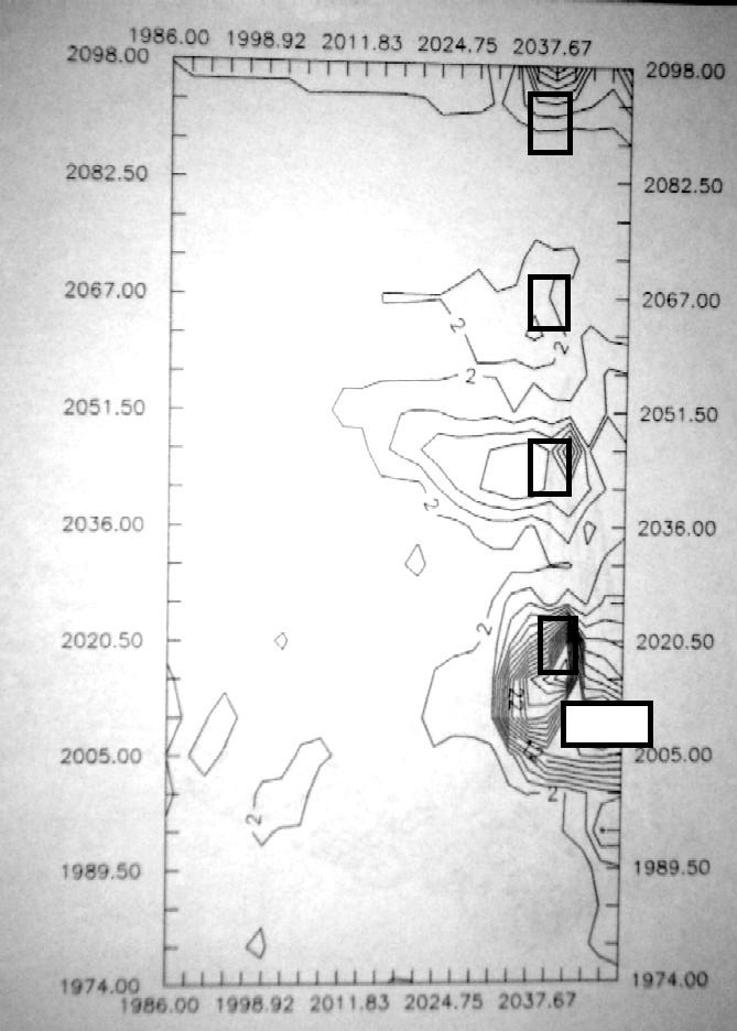
The image below shows a computer-generated "density map" of metal detector "hits" to date. For those not familiar with looking at "density maps" -- where the lines are closer together, there is a higher concentration of metal artifacts. The rectangles show the approximate locations of the existing four log cabins -- the highest density of metal corresponds with nails and other metal debris around these four cabins. The very high density at the top of the image is related to one of the cabins -- and the fenceline at the back of the yard area where garbage and debris piled up. The slight but continuous peak along the right side of the image is the current fenceline -- again where nails and other metal tends to accumulate. As we expand this survey over the next few days to other parts of the yard, we hope to see concentrations where no current buildings exist. This will provide clues to where buildings long since gone once stood.
Join us again on Friday for another update ...
It's difficult to capture the raindrops from gentle showers in a photograph... But, take my word for the fact that every photograph of the day was taken in the midst of gentle showers. The rain stopped twice today -- once during lunch and about 15 minutes after we "closed up" after a rainy day, the sun came out. Although a "soggy day" was had by all -- we managed to accomplish a lot of work under our shelters.
We continued work on the Structure 1 area today -- with some interesting new hypotheses emerging from our finds today. Our "new" fenceline mentioned yesterday (shown more clearly in the photograph below) appears to end at an interesting location...
Our "chimney base" feature is so large that we believe it was most likely a central chimney on a double cabin. Our fenceline seems to start a bit over twenty feet from the edge of that feature -- this would be a relatively standard size for a double cabin with a central chimney. So, one of our "working hypotheses" is that this might be a fenceline running off the end of such a double cabin. A hypothetical reconstruction is shown below.
Please remember that these are only "working hypotheses" constructed in the field -- our full analysis of artifacts from each excavation unit will have to be completed and evaluated before we offer our "best interpretation." This doesn't mean that we have a "constantly changing story" -- it means that we are constantly gathering new information, evaluating it, and changing our interpretations based on that new evidence.
.The artifacts from our excavations in this area continue to encourage our current interpretations of a building that was used as a domestic residence in the mid-1800s and then later used as a storage building in the late 1800s through early 1900s.
Of particular interest and encouragement today was another piece of a plate with a "maker's mark" on the back. While we haven't been able to identify precisely the several earlier backmarks, the one from today was an "archaeological gem." While you won't be able to read the mark in this photograph, it is very legible "in person." This particular plate was manufactured by the Davenport Company in Longport, Staffordshire Potteries, England -- a series of potteries in operation from about 1793-1887. The "gem" part of this particular fragment is that the Davenport mark includes the year of manufacture -- this particular plate was manufactured in the year 1852.
As our work continues, we feel more and more confident with our interpretations. Two more weeks of fieldwork will provide more clues -- and probably change our current interpretations. The labwork will begin soon thereafter and continue through October.
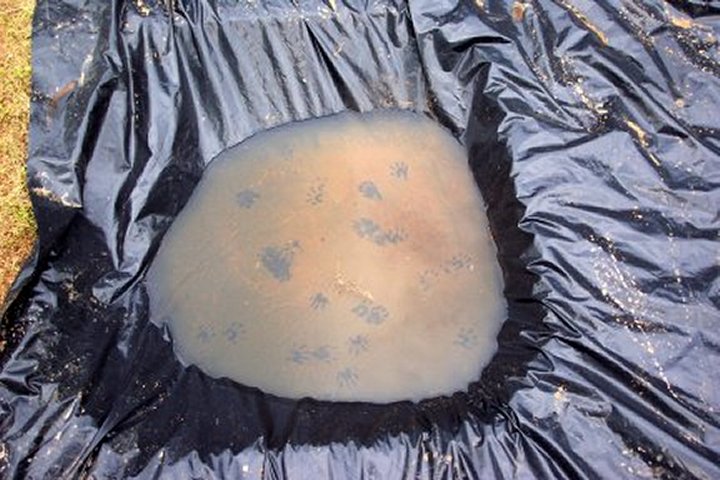
Friday evening, we had a visit from one of our local Sam Davis residents -- a raccoon who left some footprints for us on our plastic...
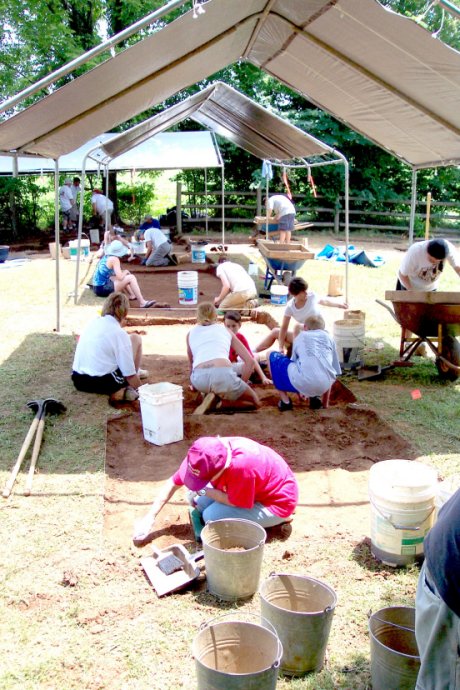
On Saturday, we hosted sixteen volunteers who worked with our MTSU students. Volunteers ranged from seasoned "volunteer veterans" to folks trying archaeology for the first time. With nearly 30 diggers and screeners at work, we moved a considerable amount of dirt between 10:00 am and 2:00 pm.
Pat and John resumed work on "Feature 14" (our "chimney base") with assistance from volunteers Dan and Chris.
By the close of the day on Saturday, the edges had been defined on the north and south -- a fairly precise 8 foot width in that direction. While more work needs to be done on the east-west edges, our early results suggest a 6-foot measurement for that dimension.
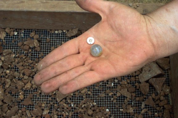
While we retrieved several hundreds of artifacts again today, a few from the "chimney area" stand out -- including many more buttons (such as the "white glass" or Prosser button below) and a glass marble.
A small portion of a porcelain doll (face) was also found today -- perhaps matching some arm and leg fragments recovered last week.
As we expanded our excavations to the west, we also found at least one and probably two more posts in our "cabin fence" -- the posts shown in yesterday's photos are in blue and those from today in white.
Looking north, today's "speculative reconstruction" would look something like this...
Only two more weeks of work on this project to go -- we have already discovered a lot of new information. More will be coming next week. For now, we close off for a well earned "day of rest."
After a brief interlude in our "field house" cleaning artifacts with rain in the morning, we moved back into the field excavations. With only a few days left in our project, we will be spending most of our time dealing with what we already have opened up -- not any new excavation units. The pace of discovery of things to investigate has been fast and furious for the past three weeks -- the rest of our brief project will be dedicated to figuring out what we've already found.
We've already opened almost 770 square feet of excavation units -- and found much more than we anticipated.
As we continued work on our "chimney base," the picture became more complex today. We discovered two sets of paired posts on each side of the feature (see photo below outlined in yellow) that will need to be investigated tomorrow. And, towards the left of the figure, we seem to have a deeper feature. The large hole at the lower left is the posthole for the modern fencepost we removed a couple of weeks ago.
Viewed from atop our handy giant ladder, you can get some sense of the complexities of what we have already investigated -- and what we still have to look at.
In other excavation areas, we continue to find new postholes, pits and other features to investigate.
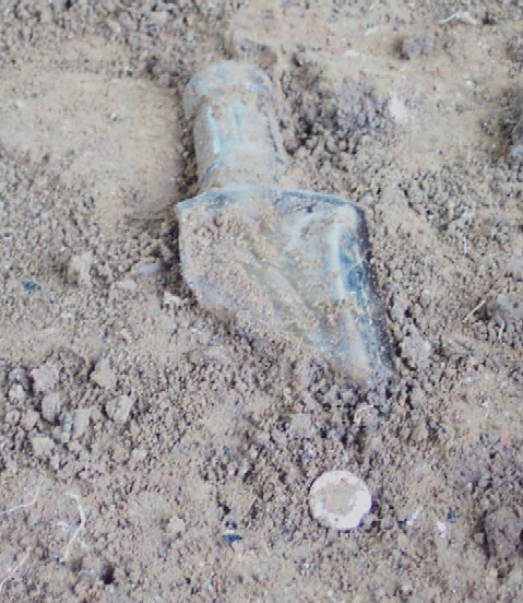
Our investigations today continue to produce new artifacts that convince us we are in an area that was a residence in the mid 1800s -- probably a slave cabin. The photo below shows a medicine bottle fragment, two buttons, and two ceramic marbles...
And the one below shows a fragment of glass tableware decorated with a floral pattern, a medicine bottle fragment, another saucer or plate fragment with a "maker's mark" and four buttons.
Our evidence converges to support our belief that we are investigating a slave residential area -- more to come in the next few days as we work on investigating the many various features that we have already found. And -- more to come in the weeks to come as we identify, evaluate and investigate the many thousands of artifacts.
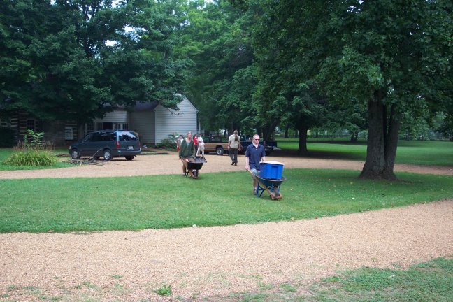
As time passes, the student crews become more accustomed to the daily routine -- the photo below shows students hauling equipment from our storage area to our excavations.
Crews continued work finishing excavations of the fenceline units today... The photo below shows Mackenzie, Cheryl, Lesley, Andy, Michael and Tracy at work in that area...
In the area beneath "Cabin 1," another crew continued work... In the photo below, Pat, Lacey, John and volunteer Howie Brainerd continue work in that area...
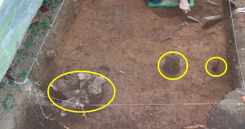
Work continued today on the chimney base of Cabin 1. While I normally try to put students on excavation of features under supervision, I took this over today. This area is so disturbed by overlapping features from many different time periods that even with my twenty years of experience in excavation and interpretation -- it is a great challenge even for me to figure out what goes where and with what. The first task of the day was to excavate the rodent burrows -- from moles, rats, mice and others. Some of these are modern and some are "ancient." Those are shown outlined in blue below...
Among the most exciting discoveries, however, was a shallow "cellar" directly east of the chimney base. These small cellars are common in slave residences in the Middle Tennessee area and were accessed through trapdoors in the floors. This cellar (outlined in yellow below) originally had a limestone lining at the top -- a few of those stones are still in place. The "rodent burrows" (outlined in blue below) all lead to the cellar. We'll have more to report on this feature on Wednesday...
Later in the day, we continued to expand our "metal detector survey grid"...
And elsewhere on the site, we decided to open one more excavation unit to look at the original yard fence starting at the "overseer's office." In this area, we hope to clarify some of the several versions of the old yard fence... Tiffany, Ryan, Lauren, and Meagan worked on this today...
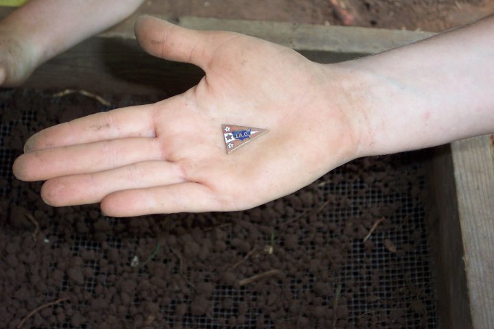
An artifact of interest recovered from this area today comes from the Daughters of the American Revolution -- the lapel pin or similar object shown below has the letter D A R in the stars at the left. And J.A.C. -- presumably a chapter of the DAR... We'll investigate this in the next few days...
Work continues tomorrow...
A very brief report today, as much of our work was "transitional" (after the morning rain)... Much of the work today was focused on expanding our metal detector survey grid...
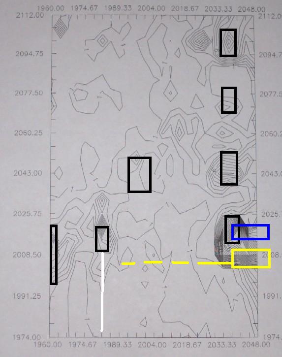
The map below shows the approximate areas we have finished in yellow (over 23,000 square feet) and the areas we hope to finish on Thursday in blue.

The image below shows a "density map" of the areas surveyed to date... Each of the existing four reconstructed slave cabins (black outlined squares) show up on the density map -- but the highest density of the area surveyed to date centers around where we believe the cluster of 1860s slave cabins once existed (our current archaeological cabin in white with a black outline). As we expand the grid over the next few days, we hope this will provide additional information on the location of the other vanished cabins...
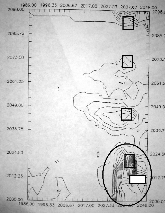
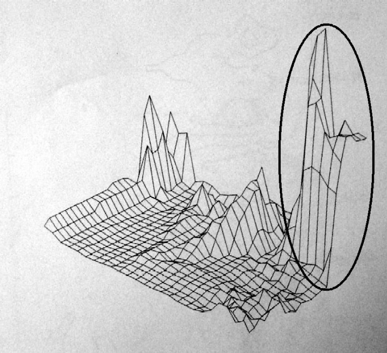
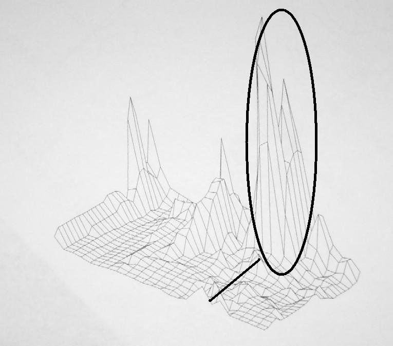
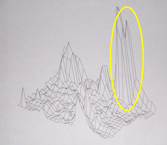
The image below is another projection of the metal detector data -- this orthographic projection shows a "3-D" representation of the metal density. The area outlined in the black oval is the "Cabin 1" area.
Tiffany, Ryan, and Meagan continued investigations of the yard fence -- with assistance from volunteers Georgia Dennis and Judy Shook. They discovered another new possible posthole (outlined in yellow below)...
This looks much more promising for the early yard fence -- our first two postholes were small and several feet out from the overseer's office (outlined in yellow). This possible posthole is much larger and directly adjacent to the overseer's office (filled yellow oval below).
More news on Thursday...
Thanks to multiple waves of rain, very little photography was done today -- but we still managed to accomplish a good amount of work (mostly by being tolerant of being soaked all day long!). Many of the students continued expanding our metal dectector survey grid -- the "sea of orange, yellow and red flags" visible in the background is about 700 points in that grid.
The image below shows the data added from the metal detector survey today... (you can compare this to yesterday's density map)... The additional data continues to clarify the very high density of artifacts in the "Cabin 1" area.
The image below is another "orthographic projection" with our new data added... (you can also compare this to yesterday's projection)... As we add new data, the image becomes more and more refined -- the oval surrounds the very high "peak" of metal in the area we are investigating; the black line appears to reflect nails along the fenceline extending from these cabins towards the overseer's office.
We did manage to continue excavations in several units beneath "Cabin 1" -- the "midden" (garbage deposit beneath the cabin) continues much deeper than we initially suspected. The photo below shows a broken medicine bottle and shell button discovered today -- probably lying where they were discarded beneath the structure in the 1800s. Hopefully, we'll have enough "rain free" time on Friday to get some better photographs of this area completed!
And finally, work was continued next to the Overseer's office on the yard fence -- two additional posts emerged in addition to the one reported yesterday (all three shown in yellow below). Not too surprising -- we anticipated that the yard fence would have been rebuilt and replaced at least two or three times between 1850 and 1925.
More news tomorrow...
Despite predictions of rain, it was a beautiful day for work at the Sam Davis Home. With only four days left in our summer field class, we are beginning to "wind down" and try to finish up the many details that will allow our lab workers to figure out what we "did in the field." We expanded our metal detector survey grid in a "big way" today...
Our survey now covers over 70,500 square feet (shown below in blue). We plan to add another several thousand square feet next week -- pending weather! New density maps and interpretations will be provided next week after I have time to digest the massive amount of new data from data.

Excavations continue on the many features in and around "Cabin 1" -- we have excavated another 5-10 centimeters in depth across this area and found several more postholes and other features. We will focus intensively on this area next week...
Work also continued today on the "yard fence" -- four additional postholes were excavated today... While future excavations will be needed to trace out these various versions of the yard fence, we now think we have at least 3 and possibly four starting points for that fence...
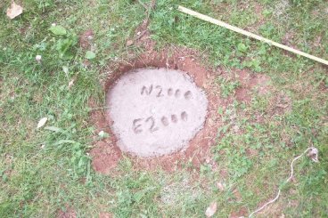
As we begin to close up our project, several different tasks have to be completed to ensure that future researchers can quickly find where we have already worked. Today, we literally set our "invisible grid" in stone -- four of our gridpoints were marked with cement markers. Below, assistant Chris Hogan is preparing the holes for one of these benchmarks...
A finished product is shown below -- the hole is filled with cement, a brass pin is placed, and the gridpoint is labeled. The markers are below the ground surface so they won't impede mowing. Gradually, they will be covered with sod -- but should be fairly easily relocated in the future from our notes.
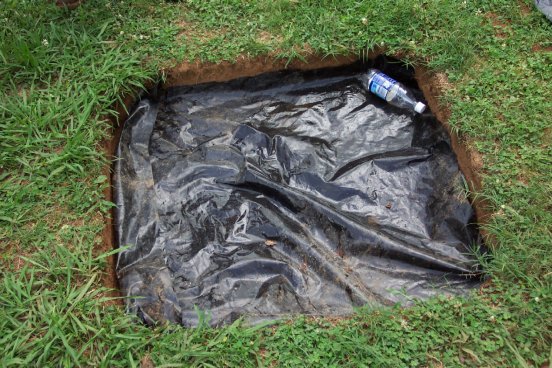
Other activities include marking our excavation areas and restoring them as closely as possible to their original appearance. The photo below shows one of our excavations units "ready" to be "backfilled." The bottom of the unit is lined with black plastic and then covered with dirt. The plastic bottle at the upper right of the unit contains a cloth tag labeled with the size of the excavation, grid designation, and other information.
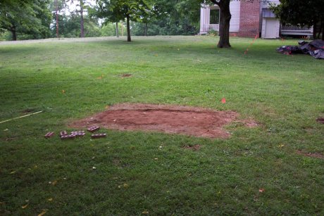
The photo below shows one of our completed excavation units after "backfilling." The sifted and aerated soil will provide a good base for grass -- although a small amount of settling may occur, hopefully the only evidence of our excavations will be a shallow depression.
We're all thankful for a "three day weekend" before we dive into the last four days of closing out our project. We've made great progress in the past four weeks -- hard work has resulted in many new discoveries alongside some practical field experience in archaeology.
Once again, we missed the rain today -- by only a few minutes. The storms arrived about 10 or fifteen minutes after we closed up work today...
Most of the students were engaged in expanding our systematic metal detector survey today...
The "3-D" representation below shows the same information in a different format -- again, the yellow oval outlines the incredibly high peak of metal artifacts surrounding the area we're working in. Not an unexpected "high" for an area that may have housed as many as 30 of the 50 slaves.
"Cleanup" work also continued on many of our posts and other features... The photo below shows a cedar post in the fenceline we think extended from the slave cabins to the old yard fence. Excavating posts like these is not exciting work -- no artifacts and few rewards. But, recording the size of the posts, their depth, and other information allows us to sort out the multiple fencelines and their posts.
Similar work continued on about half a dozen postholes in and around our cabin... The two shown below were excavated today...
Weather and our work permitting, we'll hopefully have some new "aerial shots" of Cabin 1 for you to look at on Wednesday evening. Work continues in this area daily... The photo below shows a new fragment of a plate with a backmark. What is left is from "Charles Meakin" -- a potter who worked at two potteries in England during the late 1800s. This particular mark dates between 1870 and 1882, when he worked in Burslem. This -- along with other artifacts -- supports our belief that this cabin was occupied between 1850 and 1925. It was probably the "double cabin" occupied by "Uncle Charlie" from about 1900-1925.
And, as we continue to excavate beneath Cabin 1 -- we also continue to find "treasures" like the marble shown below.
With only three days left... we are hard-pressed for time to finish our work. But, with the dedication of our student crew, we shall persevere! Weather permitting, we'll have some aerial shots showing our recent work by tomorrow evening.
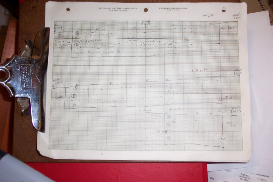
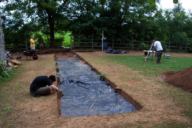
Much of our work today revolved around completing the tedious tasks of paperwork -- making sure that we have recorded everything properly and thoroughly before we backfill the excavations. Archaeology is a "destructive science" -- unless we carefully record everything as we excavate, that information will be lost forever. So, while tedious, our "paperwork" is one of the most critical parts of our work. Below, most of the students are involved in recording the "profiles" of our excavation units -- the different "layers" or strata of soil and sediment uncovered during our excavations. This information will be critical in interpretations of our excavations -- and for future research.
The end product is a detailed record of the "sides" of each excavation unit -- like the profile drawing shown below.
Despite all of the disturbance from 20th century fencelines, planting holes, waterlines, trees -- and a host of local rodent residents past and present -- we have accumulated sufficient evidence from our investigations to feel certain we have found one of the main areas where slaves lived during the mid-1800s and where tenants continued to live throughout the late 1800s and early 1900s.
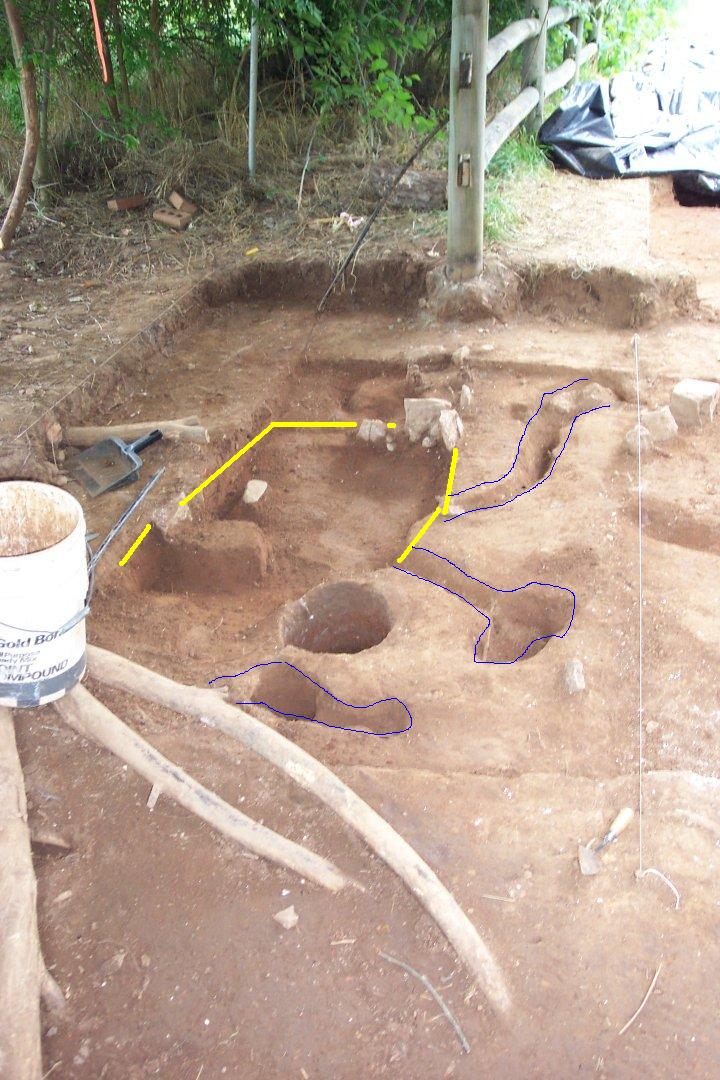
While we will wait until our laboratory analysis is finished to offer a firm "final hypothesis" from our summer 2004 field project -- the image below shows our tentative (and as yet somewhat speculative) conclusions... Outlined in blue is what we think was the remnants of a base for a large central chimney... Outlined in yellow is what we are fairly confident was a shallow subfloor storage cellar (located in front of the hearth)... And the white lines show where the cabin walls would have stood in relation to these features. As we analyze the artifacts, we anticipate that their distribution may tell us something about the location of doors and windows and other features...

On Thursday, we'll be closing out our notes and records -- and starting to put the dirt back in the holes.
Our "next to last day" for our summer field project at the Sam Davis Home was almost perfect -- a relatively cool morning to finish paperwork, no rain, a brief hot spell in the early afternoon, and then a relatively cool late afternoon (relative to what July can be anyway!). In the morning, we worked on finishing our mapping and record-keeping -- double-checking all of our forms and drawings to make sure we hadn't overlooked something. Other students worked on completing our metal detector survey grid to cover the entire eastern yard area. Others worked on preparing our excavation units for backfilling.
"Backfilling" is the bittersweet end to a field project -- for five weeks, we have worked carefully to remove the dirt from across the landscape of the Sam Davis, sifted it to retrieve artifacts, and discovered the features beneath that survive to tell us about the past. Today, we began to "un-do" all of that work -- putting the dirt back where we so carefully excavated.
We are pleased and excited by what we were able to discover in only five weeks -- what we have learned about the past residents and the landscape of the Sam Davis Home, what we have discovered about "archaeology," and what we have discovered about working as a "team." Putting the dirt back into our so carefully investigated and recorded excavations is a "rite of passage" in many ways -- it provides an exhausting and poignant closure to our intensive interactions over the past many weeks.
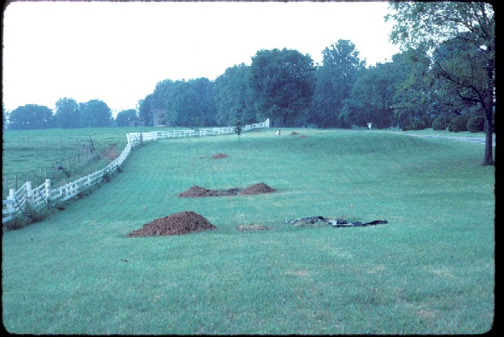
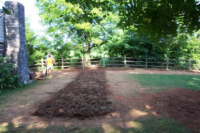
As shown in the photograph below, on June 9 we were just beginning our investigations at the Sam Davis Home...
As shown in the photograph below, yesterday our excavation area looked like this...
Most of us stayed until 5:30 pm today to finish filling our excavation area -- most of us will remember this in painful ways in the morning! As the photo below shows -- we have restored the area as closely as possible to they way we found it. The fence is back up, the units filled and covered.
On Friday -- our final day -- we will be cleaning our equipment, work areas, and loading up to return from the Sam Davis Home to Middle Tennessee State University. That will be our final entry for fieldwork this summer -- but labwork will begin next Monday on washing, cataloguing, and analyzing the thousands of artifacts recovered.