June 2-July 3, 2003
|
| The Old First Presbyterian Church Archaeological Project June 2-July 3, 2003
|
On June 2, we were in the classroom on the MTSU campus from 8:00 am until
noon for an orientation presentation. We arrived on the site to start the
project at 1:00 pm. The first goal was to establish a "site grid" -- the
basic north/south system used to establish all excavation units and
mapping for the project.
Unfortunately, the rain arrived earlier than predicted -- it started
drizzling by 1:45 and kept up until we were forced to terminate our field
operations around 3:00 pm.
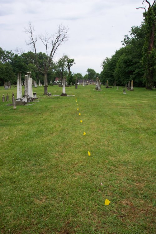
We were able to etablish the beginnings of the grid system for recording
before quitting early for the day. Grid points will be marked at 2-meter
intervals across the entire area we will be investigating. Reference
points are marked with yellow pin flags.
With great patience, the student crew waited out the morning rain today. While the official rain gauges may show less, our unofficial "bucket gauge" accumulated about 2 inches of water between 7:15 and 10:30 am. As the drizzle continued, we completed half of the "site grid" before breaking for lunch early.
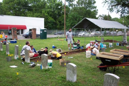
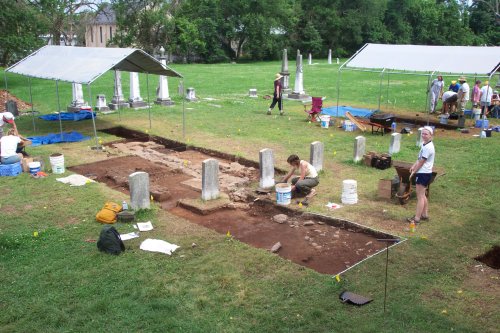
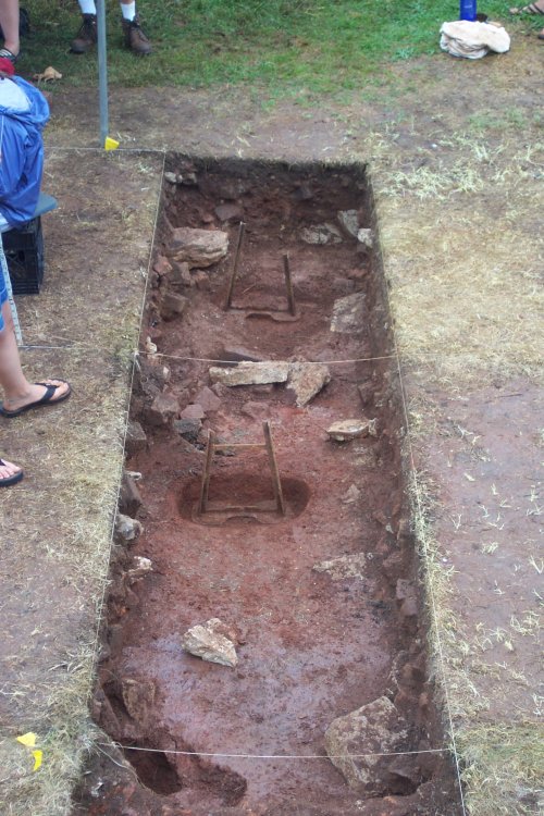
After lunch, we were finally able to begin excavation. The seventeen students in the class are divided into six "excavation crews." In order to locate the foundation of the church, we began a series of excavation units at the edge of the church lot running east-west. The excavation units are 1-meter wide and two-meters long -- effectively creating an excavation trench about 25 feet long. This trench should cross the east foundation of the church building. Another shorter trench to the south (about 15 feet long) will hopefully intersect the southeastern corner of the church.
Just beneath the sod (about 2 inches deep), we immediately began encountering what appears to be the remains of the church building. In the long trench, large brick fragments, pieces of limestone (probably scattered debris from the church foundation), and square nails dating to the 19th century started turning up right away.
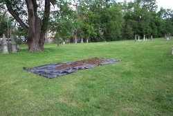 Soil excavated from these units is screened through 1/4 inch hardware mesh to recover artifacts. After processing, the soil is "stockpiled" on a large sheet of plastic well outside our excavation area (and away from existing grave markers). At the end of the excavation, this soil will be replaced in the units and seeded with grass to restore the area as closely as possible to its original appearance.
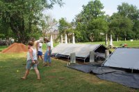
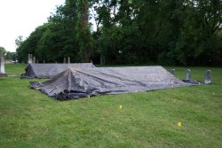 At the close of each workday, the excavation units are covered with a protective canopy -- the remains of the church are protected from the elements beneath the soil. As we expose them through excavation, we have a professional obligation to protect them from the potentially damaging effects of sun and rain. As the excavations proceed, these canopies will also help protect the unsuspecting local pets and local wildlife from stumbling into a deep hole! Despite the poor weather on our first two days, the excavations are now underway and show great promise to produce some new and exciting information about the 1820 First Presbyterian Church.
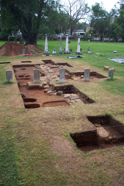
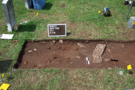
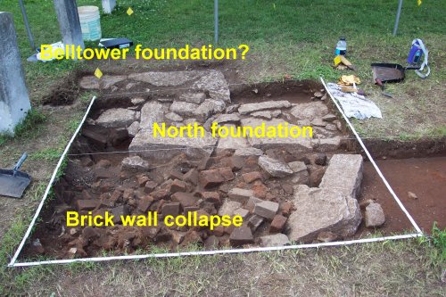
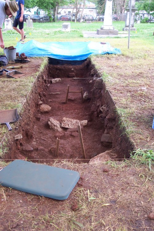
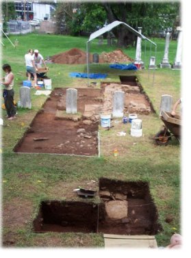
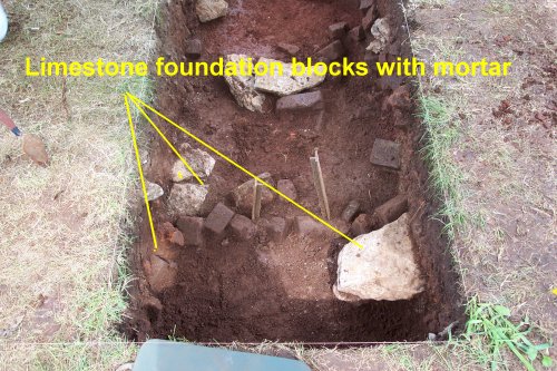
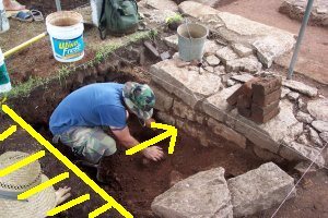
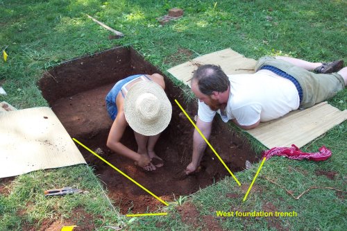
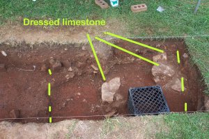
At the bottom of this level in one unit (see the photograph below), we found what may be the remnants of a foundation wall of the church. In the right of the excavation unit, you can see two large cut limestone blocks roughly in line. Just to the left in the photograph is a scattering of bricks and brick fragments (some still coated with mortar) -- their placement in the ground suggests they were tumbled away from the possible remnants of the foundation. On Thursday, we will be excavating Level 2 (10-20 centimeters -- about 4 to 8 inches deep) -- that should answer the question of whether these are the remains of a foundation associated with the church.
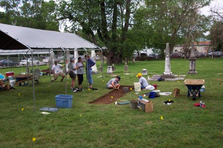
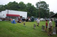
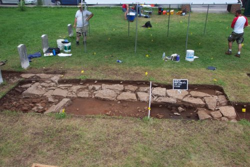
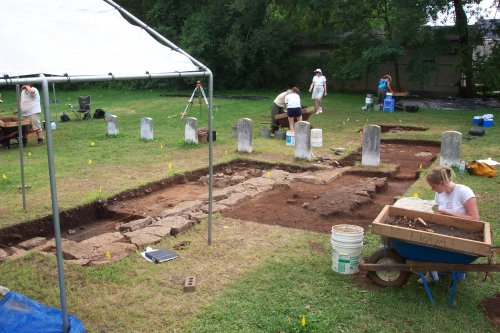
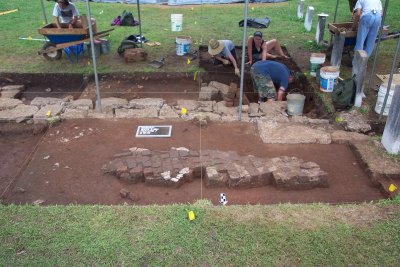
 The weather was much more accomodating for archaeological work today. As shown in the photograph to the right, crews worked in two areas removing "Level 1." Students carefully remove the dirt in "levels" -- each level is 10 centimeters in thickness (about 4 inches). Level 1 includes the sod and a zone of humus (topsoil) containing a mix of artifacts from the 1800s and 1900s. In this mix, we found round or "wire" nails (dating primarily after the 1880s) to square nails (the older type), relatively recent crown bottle caps and fragments of Mason jars, fragments of 1850s ceramic dishes, and many other items.
At the bottom of Level 1 in all six of the units, we appear to be working in deposits that date primarily to the mid-1800s -- the more recent artifacts are declning in frequency. Level 2 promises to be a much less disturbed -- and will probably date to the period around the time of the destruction of the church.
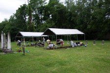
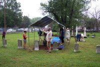
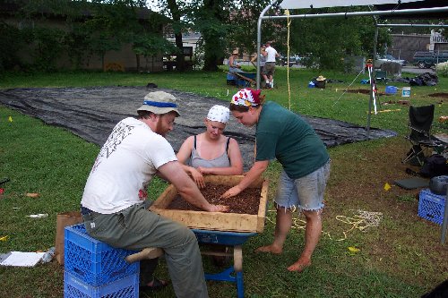
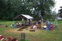
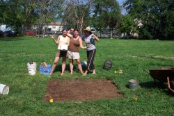
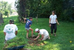
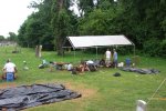
Students comprising the crew are "learning the ropes" of how to do archaeology, identify artifacts, and keep records. The following two photographs show "The Crew" at work.
Thanks to a beautiful day for outside work, we were able to make great progress today in the on-going excavations. The first photograph below shows students working on the first trench -- the cut limestone blocks in the center are the foundation for the east wall of the church. The large cluster of bricks being carefully exposed by students in the lower part of the photograph is the remnants of the east wall of the church, tumbled into the interior of the church during its destruction. This "level" (see June 4) appears to be undisturbed since destruction of the church in 1864.
Amongst those mundane artifacts is occasionally a "special item" -- nothing of great monetary value, but something that reminds us of the people who lived before us. The tiny plastic charm in the shape of a harp shown below is an example of one of those artifacts. Because it was found in one of the Level 1 mixed deposits in the yard of the church, I'm not sure of the date of this artifact yet (no time for research on artifact types while working in the field!). Nonetheless, it does give one pause to discover such an intriguing item amongst the window glass, brick fragments, and chunks of limestone.

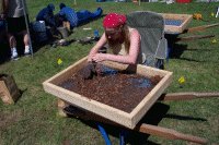 All soil from the excavations are processed through 1/4-inch hardware mesh to recover artifacts. The process is tedious and time-consuming -- most buckets are full of 60% dirt; 39% brick fragments, rocks, and gravel; and 1% artifacts. The "science" part of archeology requires recovery of each fragment of glass and ceramics, nails, mortar, etc. While seemingly mundane and boring to find and record, something as simple as the quantity of window glass in a unit gives clues to the location of windows. Measurements of the thickness of that window glass can provide clues to the dates of construction and renovation of buildings like the church.
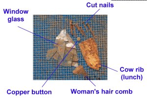 The photograph to the left shows a selected set of artifacts from a single level in the excavations. While perhaps not as visually exciting as those objects selected for a museum display, as the analysis proceeds in the laboratory each of them will provide critical information about the church building and activities associated with the church. The glass, nails, bricks, and mortar recovered give us detailed information about the church architecture -- things that were not considered important enough by the builders to write down for us today. The types of buttons, combs, and other personal items tell us about how the people who met at the church dressed and presented themselves.
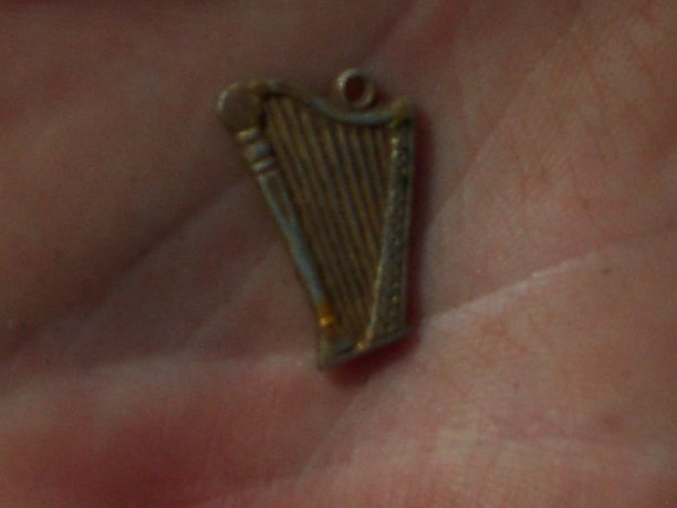
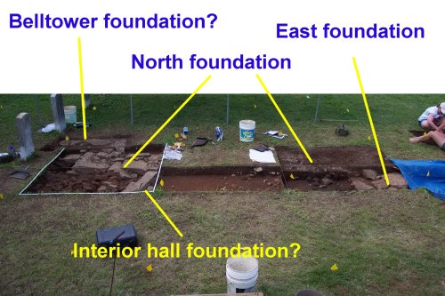
Several crews continued work on Level 3 -- a section of the eastern wall foundation was fully exposed in one unit. The section of foundation discovered earlier in the week now appears to be an interior foundation associated with the central hall of the church. A perpendicular foundation wall segment is either the north wall of the church or (more likely) a section of the belltower foundation. Unfortunately, the rain started before I shot digital photos of these features for the web pages.
 The rain started about 2:15 pm and did not appear to be letting up, so we closed up the excavations early for the week.
Another beautiful day for archaeological fieldwork at the Old First Presbyterian Church site. We made some excellent progress today on exposing the northern 1/3 of the church structure.
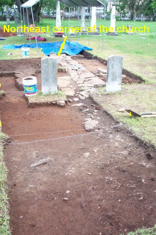
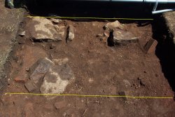
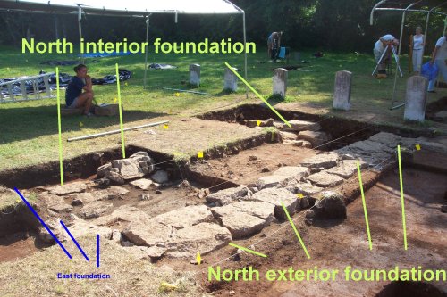
As shown in the photograph below, we have located the northeastern corner of the church -- including a 2-meter long section of the east wall and a 6-meter long section of the north wall. In addition, another likely foundation wall (needs a little more digging before we can be certain!) is probably an interior foundation for the eastern church gallery. An extension of the north foundation uncovered today is probably the foundation for the church belltower -- a feature that reached 70 feet into the air.
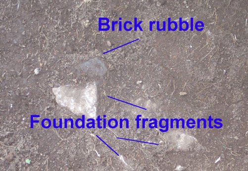
A closeup of one of the excavation units shows the foundation features in more detail. The brick rubble in the foreground of this image is a pile created during the demolition of the church in 1864. An interesting thing to note -- if you look carefully, you will see that there are no whole bricks remaining. This tends to support a letter written by one of the 1860s church members stating that the bricks were carted off to be used by soldiers to build chimneys and ovens for their winter "huts." The winter of 1863-64 was particularly harsh and soldiers stationed in the area were undoubtedly desperate for some relief from the winter chill. At this early stage, it does appear that the whole bricks were carted off -- and all we have remaining in the rubble are broken fragments.
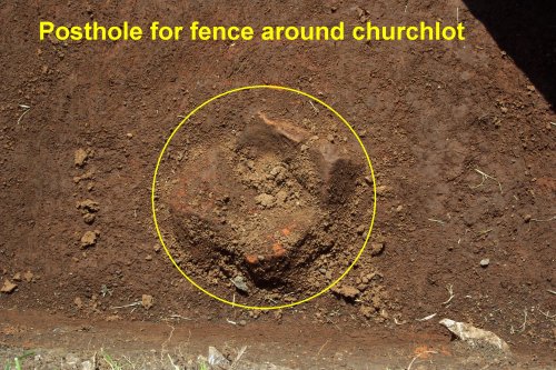
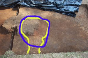
Another existing find of the day was a probable posthole filled with brick rubble -- highlighted in the photograph below. No really, it is exciting! While not perhaps as visually stimulating as solid limestone blocks in a church foundation or as intriguing as a tiny harp charm, one of our project goals is to locate where the fence surrounding the church lot was located -- and what it looked like. The brick rubble was probably packed into the the hole created when this post was removed sometime between 1862 and 1864. At a time when horses were a prominent means of transportation, leaving gaping postholes in the yard surrounding the church would have not been a good idea! The size of the posthole and the spacing of these holes will give us a good idea of what the fence looked like. We also hope to be able to find the original gates in the fencelines by the spacing of posts.
We are continuing and starting excavations in several other areas not shown in today's photographs. One crew continued work trying to locate the base of the pulpit in the south-central portion of the church. the pulpit was a substantial feature of the church -- standing three feet in height, long enough to seat three people, and with two stairways. We hope that it was substantial enough to require a stone or brick foundation that will remain for us to find. Another crew continued working to locate the south wall of the church -- but hasn't gotten deep enough to expose it yet. Yet another crew started work exposing the northwest corner of the church. And yet another crew started work to find the second posthole in the fence surrounding the church lot.
If the rain doesn't come too often as the week progresses, we should be posting photographs of several of the parts of the church as the week progresses.
Today started off well, but ended with our first
"severe weather" test.
In the morning and early afternoon, crews continued investigations of the
north foundation of the church -- exposing another 4 meters.
The northwest corner of the church is buried rather deep -- another crew
continued excavations to expose it, but didn't reach it yet.
Another crew continued work trying to locate the second posthole for the
fenceline surrounding the church lot -- but didn't quite reach it yet.
Work on finding a second portion of the eastern wall of the church met
with little success today -- as (bad) luck would have it, our excavation
unit appears to have been placed in a section where all of the foundation
blocks were removed. We will have to start another excavation unit to hit
that foundation wall.
The crew searching for interior features (such as the pulpit) has one of
the "toughest" jobs -- this part of the church interior has been covered
over some very dense clay at some point in the recent past, making
excavation very difficult. However, we have finally gotten through most
of that "crap" and some promising patterns of brick have emerged.
The crew working to locate the south wall continued their work -- still
not deep enough. The overlying soil is much deeper on the south half of
the church, but we are confident that we'll be down to it soon.
Sorry folks, no photos tonight -- in the mid-afternoon, an unexpected
thunderstorm blew in very rapidly and we had to close down operations
early once again. Thanks to our early warning system, we were able to get
our excavations covered quickly and dismiss before the storm actually
arrived. The crew performed admirably with short notice.
Wednesday started off as what we might call "humidity
challenging" for archaeology. It's hard to get the day off to a good
start when things are already steaming at 7:30.
In the early morning hours, crews completed exposing the eastern half of
the north wall of the church.
The crew working on the northwest corner met with some disappointment
today -- we were trying to open the smallest possible excavation unit to
hit the corner of the foundation. We missed it by about two inches in
that unit, and will have to start a new excavation to the south to expose
the corner.
The crew searching for the second posthole for the church fence got deep
enough to expose an intriguing cluster of limestone and brick that looks
promising to be that very posthole -- if so, the fence posts were eight
feet apart.
The crew searching for the interior features started removing the brick
rubble from their units, but no clear patterns have emerged that would
suggest interior features yet.
The crew working to locate the south wall continued their work -- still
not quite deep enough -- although quite a bit of limestone fragments
that are probably part of the foundation were exposed today.
Unfortunately, we had very little time to work in the field today.
Mother Nature sent the showers our way about 10:30. We broke for an early
lunch about 11:15. By noon, the storms were starting to blow in, and we
were forced to close up.
We retreated to the MTSU campus and washed artifacts until 3:30 pm.
While most of our artifacts are probably mostly of interest only to the
archaeologist, a few interesting items do appear in the lab. From the
upper mixed zone of older and newer artifacts, we recovered a corroded
bottlecap with enough surviving paint to read "Ski". Not being familiar
with a soda called "Ski," I did a quick search and discovered that in
April 1937, Edward Meier opened the Excel Bottling Company in a small town
in southern Illinois -- making Ski soda, which is not marketed very far
outside Clinton County. How a bottle of Ski soda made its way from
southern Illinois to the Old City Cemetery in Murfreesboro gives us a
chance to create some entertaining speculative stories -- and ask some
interesting questions as well.
Here's hoping that the journal entry for June 12 will include fewer
mentions of rain and some better progress on our investigations.
Finally, I can report another lovely day for archaeology in the 'Boro! After a couple of days of on-and-off rain, we were (almost literally) giddy with excitement just to have a chance to excavate the whole day without getting soaked once. So, for the first time since Monday, a few "photos of the day."
The photo below shows the exposure of about 1/3 of the front (north) foundation wall of the church just before lunch today -- after cleanup.
The photo below -- taken from the same vantage point -- shows the excavation area as it appeared on Monday. Archaeology is slow and tedious -- but a group of students working carefully and learning quickly produces great results.
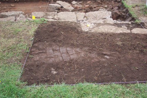
After lunch, we started stripping the sod from a series of three 2x2 meter square excavation units to expose the remainder of the belltower foundation and to look for the foundation of the stairs leading into the entry hall of the church. Given that this constituted stripping sod from about 130 square feet, we hadn't anticipated any great new discoveries today from this operation. But, unexpectedly, just beneath the sod, we found what is either a brick "patio" or brick pathway in front of the church (shown in the photograph below). One never knows what might be concealed beneath a tiny bit of grass. If the weather holds, we will report more on this feature on Friday.
A couple of interesting "artifact notes" for the day. In the southernmost excavation units (searching for the south foundation wall), two exciting types of "architectural" artifacts were discovered.
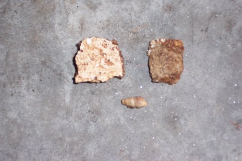
The first discovery was several large fragments of wall plaster -- an artifact indicating that the interior walls of the church were covered with a prepared and smoothed surface (instead of just brick). We had suspected they were, but none of the documents record that information. The photo below shows a fragment of the finished interior plaster (upper left) and the reverse unfinished side (upper right). This discovery also explained one of the questions about the "artifacts" we've been finding. We have been recovering a large number of freshwater gastropods (the tiny corkscrew shaped snails that live in our local streams -- lower center in the photo below) from many of the excavation units. How and why so many aquatic snails got to the church site was a question we had no answers for until today. The fragments of wall plaster discovered today include tiny gastropods -- we now believe the sand used to mix the plaster and probably the mortar for the church was gathered from a nearby stream (perhaps Lytle Creek). The gastropods were in the sand gathered, and ended up in both the plaster and mortar -- most of that plaster and mortar has "rotted away" leaving the tiny water snails for us to find. One mystery solved!
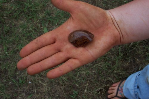
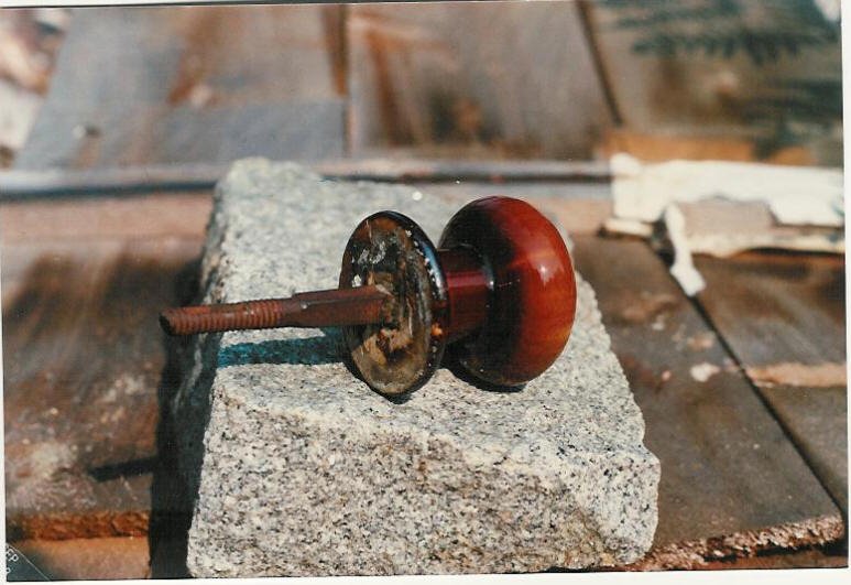
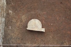
The second "architectural discovery" was a fragment of decorative earthenware (pottery) in an unusual form (shown in the photo below). While not entirely confirmed yet, it appears to be about 1/4 of a fairly fancy doorknob -- probably produced in the first half of the 1800s. We'll be watching carefully in that excavation unit for the rest of that artifact! A possibly similar doorknob is shown in the second photo below.
Friday the 13th proved to be another nice day -- although the mix of heat and humidity at the end of a long week left everyone happy to close up at day's end!
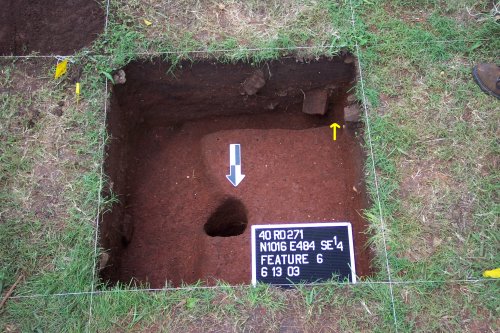
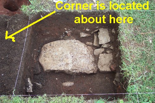
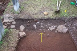
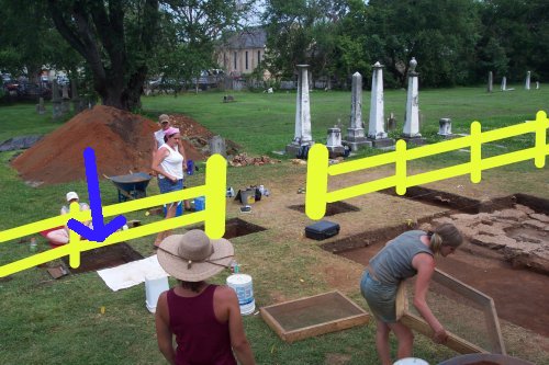
The crew searching for the northwest corner of the church foundation completed their 1x1 meter square unit today -- including excavation of two features. We missed the foundation stones by a few inches, but did excavate the "builders trench" for the foundation -- the trench excavated to place the foundation stones. The excavated trench ends at the yellow arrow in the photograph below. The black and white arrow points at a 123.5 cm deep hole -- we originally thought this was a posthole at the corner of the church. But, after excavation, it seems more likely that it was the taproot for a large tree. The crew has started a new excavation unit that should reveal the corner on Monday.
Crews working on the southernmost excavation units on the inside of the church continued working their way through the 50-centimeter thick deposit of brick rubble, plaster, and mortar from the destruction of the church. After several days of dealing with this mish-mash of demolition debris, they finally exposed what appears to be part of the interior foundation wall for the east gallery. More on that Monday.
The crew working to find the south wall of the church continued excavating through the thick deposit of destruction debris -- and finally got down deep enough to reveal what appeared to be the trench for the foundation wall. On Monday, we'll hope to get down to the actual surviving coursework.
In the units started yesterday at the front (north) of the church, two crews continued working their way through Level 1 - the upper 10-centimeters of relatively recent deposition. More of the north foundation wall is emerging, but won't be added to our photographic report until Monday.
However, we did discover a fragment of a commemorative marker in one of those units -- barely covered by the grass.
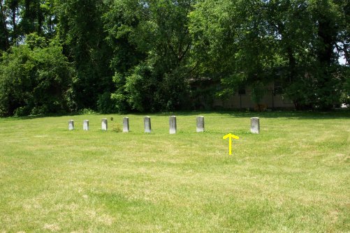
The photo below shows the row of Revolutionary War markers as it appears today -- the yellow arrow shows the location of a missing stone. The stone was placed in the cemetery by the Captain William Lytle Chapter of the Daughters of the American Revolution in 1937 -- it didn't mark an actual grave, but was just placed to commemorate this soldier, who is buried about three miles from downtown Murfreesboro near the National Cemetery. The stone vanished from the row of markers sometime between November 1968 and October 1976.
The missing marker was for Samuel Wilson who died 11 September 1830. In 1968, the marker was recorded by Jill Garrett as already broken and in bad shape --the fragment of marker found today only a few feet from its probable original location (see photo below) appears to be a fragment of the missing stone.
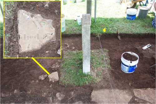
The fragment will be retrieved -- possibly additional fragments will be discovered as the excavations continue. If we have really great luck, maybe we will be able to find enough to piece some portion of this stone back together.
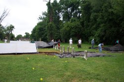 At the end of Week 2 of the FPC Archaeological Project, we have made some great progress in "re-discovering" the remains of the church. At right, the students are carefully covering the excavations for the weekend. Three weeks to go -- and many more discoveries await us. But for now, the Project Director is off for some "R&R."
Thanks to the cooperative weather despite the gloomy predictions, we were able to put in a full day's work at the site today. A bit on the humid side -- but thanks to a couple of visitors to the project bearing gifts of popsicles in the afternoon, the crew worked up a storm. The only major downside was the discovery of our project crew by a horde of what might politely be described here as "some gosh-darn biting flies." Amazing that such tiny critters can actually "levitate" a human being two-three feet in the air with a single bite. Many of them perished in their assault on the crew today. I'll leave the less polite references to them to your imagination.
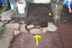
The crew searching for the northwest corner of the church foundation excavated about 18 cubic feet of soil today to get down to the foundation wall shown in the photo below. Although difficult to tell in the photo, the tops of the remaining foundation stones are about 2 feet below the ground surface in this part of the site. The corner of the church foundation is located in the next excavation unit to the west as the arrow indicates -- if the weather permits, we will expose that corner on Tuesday.
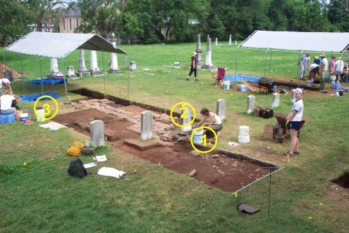
Crews working on other areas of the north foundation of the church continued work today. We now have almost 37 feet of the north foundation wall exposed or partially exposed (as shown in the photograph below) -- only one more excavation unit to expose the remaining 3 feet. The apparent "tombstones" directly adjacent to the excavations in the photograph are -- as noted earlier -- commemorative markers for Revolutionary War soldiers placed by local chapters of the Daughters of the American Revolution. They do not mark actual grave sites. We are however, leaving an unexcavated area around these markers as we proceed so that the bases of these stones remain intact.
A closer photograph of the newly exposed segment of foundation is shown below. While most of the larger foundation stones are not yet exposed, the trench for the foundation is already clearly visible -- the darker soil in the trench (filled with scattered limestone fragments) contrasts clearly with the lighter colored soil without limestone fragments. The yellow arrow points to the transition between the trench and the undisturbed soil.

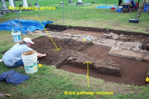
A bit to the east, another crew completed work on their excavation area containing both portions of the north foundation and the brick "pathway" remnant. In the first excavation unit, this feature has been heavily disturbed -- only the small portion in the photograph below remained intact. They have now opened the next excavation unit to the east (left in the photo below). More of the brick "pathway" is already showing up just beneath the sod. Over the next few days, we will be focusing on following this feature in the excavations.
The three crews working on the interior and the southern wall of the church have a much more difficult task in some ways -- and haven't yet received full recognition for their hard work. Similar to the northwest corner mentioned above (at about 2 feet below surface), the southern portions of the church are buried much deeper than most of the foundation stones on the front wall. The three crews working on the south have had to carefully work their way through over two feet of brick rubble over the past several days. They appear to be almost finished with the "demolition zone" -- and hopefully we'll finally be able to feature some of their discoveries in the next day or two. As you may be able to see in the photograph below, the walls of these excavations units are packed with brick and limestone rubble from just below the sod to the bottom. The limestone block fragments in the bottom of these two units may be part of two interior foundation walls for the church -- one running north-south and the other east-west. The two metal objects shown in the photo are an intriguing set of artifacts that remain to be identified. The next day or two should (finally!) answer some of those questions.
As the crew members demonstrate in the photo below, each and every bucket of soil taken from the excavation is processed through 1/4-inch hardware mesh to recover all artifacts from the mundane to the intriguing.
As each day passes, the crew members quickly become more and more experienced and confident as archaeological field technicians -- although we are almost halfway through our project, the pace of discovery continues to increase.
The weather report of the day: 100% Muggy. While the rain missed us once again, work is proceeding slowly today as we try to figure out a number of irregularly shaped stains in several units. Thus far, most have proven to be natural features (ancient tree roots and the like) or fairly modern intrusions (holes dug into the lower areas that contain 1950s bottle fragments, etc.). However, each of these features has to be investigated -- on the chance that it relates to the period of the church.
Our first photograph (looking southeast) shows the north wall excavation -- and gives some idea of the scale of the expanding investigations of the front of the church.
The second photograph is looking due east down the entire length of the front wall.
Our third photograph (looking southwest) shows the front area from another angle -- the brick pathway in the center of the photograph is poorly preserved, but emerging.
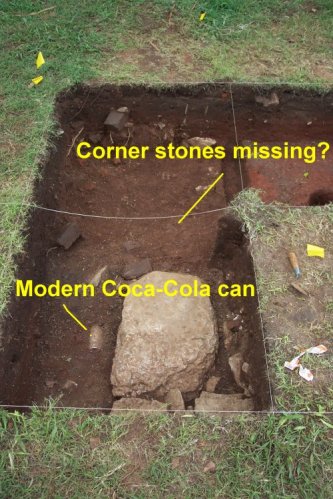
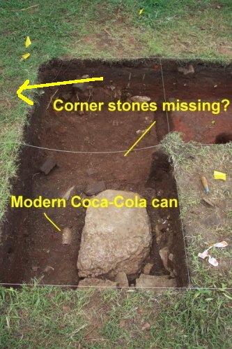
Unfortunately, as the crews searching for the northwest corner reached the level where the foundation stones should be, we discovered that the stones have apparently been removed from the northwest corner -- this may have happened at the time of the destruction of the church, or at a later time. A modern Coca-cola can adjacent to the surviving foundation stones indicates that the area has been disturbed in relatively recent times. Fortunately, however, the trench in which the stones once stood remains definable by archaeological standards.
In the interior of the church (the "southern excavation area"), a limestone block feature has finally appeared at over two feet below the current surface. The last photograph for the day shows the intact parts of the coursework -- these stones still have mortar in place on the tops, and probably represent the foundation for the eastern gallery of the church.
Overall, another good day for archaeology at the Old First Presbyterian Church site. The rain held off until mid-afternoon -- and we were only interrupted for about half an hour by a short but drenching downpour.
Today was a "transitional day" for us -- we shifted all of the crews to the northern part of the church in order to maximize our ability to work under our shelters during brief rainy periods. Also, before we open some additional excavation units to identify the southwestern and southeastern corners of the church foundation -- we need to confirm the northwest corner location. After we are certain of the location of the northwest corner trench (despite the missing foundation stones), we can then more precisely place excavations to locate our two remaining corners.
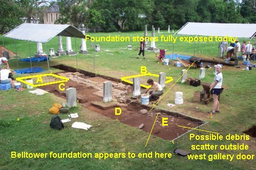
Once again, the rain caught me once again before I snapped a few digital photos for the web page, but the edited photo from yesterday shows the locations of our new investigations -- and where two crews continued work today. We opened the 2x2 meter unit marked "A" in the photo to see if the brick "pathway" feature continued to the east -- by the close of the day, it was already apparent that this feature either doesn't continue there or has been destroyed by later disturbances. This unit should also reveal some features relating to the entrance to the eastern gallery. Documents indicate the church had three entrances -- the main entry in the center, and two doors entering the galleries on the east and west sides of the church. In the area marked "C" in the photo, the crew continued to "dig" this area.
The 2x2 meter unit marked "B" in the photo was opened to follow what we believe is the belltower foundation and investigate the immediate interior of the church main entry door.
In the area marked "D" in the photo, the crew completed exposure of the cut limestone blocks of the foundation -- like the northwest corner, this section of the foundation is missing a large number of stones in the upper courses. However, there are three courses (or layers) of foundation stones below the surface of the church site -- in this section of foundation trench, at least one course of stone is intact (I'll include some photos on Thursday to better illustrate this).
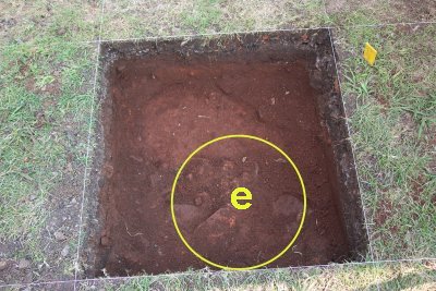
In the 2x2 meter unit marked "E," it appears that the foundation stones for the entrance and belltower end -- although this will have to be confirmed in the next day or two. No sign of a "builders trench" or stones appeared today. However, a scatter of debris in this unit may represent a depression associated with the door into the west gallery. Again, further investigations this week will hopefully tell the tale.
On the northwest corner, the crew confirmed today that all of the corner foundation stones have been removed sometime in the distant or recent past. They will start excavations to the south of the "corner" on Thursday (follow the yellow brick arrow in the photo below) to reveal what we hope will be preserved foundation of the west wall.
Give us another good day of work, and we'll have some new and exciting photos to show!
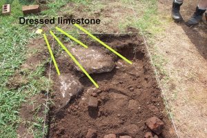
The brick feature in the yard directly in front of the church is only partially preserved and remains something of a mystery (see photo below). It seems to be a remnant of a brick pathway or small "patio" area - but when it was constructed is uncertain. At this point, we don't believe it dates to the period of the construction of the church. The low quality of the work in the pathway/patio (broken bricks pieced together) doesn't compare well with the extremely high quality work evidenced in the church itself. While it would have been functional as a pathway or patio, it certainly wouldn't have been very "pretty" compared to the church. In addition, a feature we think does relate directly to the church -- either a pillar base or posthole -- extends "under" the bricks. If forced to hazard a guess at this point, I would suggest that it is a feature added by soldiers during the Civil War.
 With only a very brief little shower this afternoon, we had a great day for archaeology in the 'Boro. The front wall of the church is shaping up nicely with a lot of hard work by the crew.
Work continued today towards full exposure of the north foundation walls. The two images below show "before" and "after" of the same excavation unit -- the arrows are pointing at approximately the same point on both images. The image on the left ("before") is from June 16 showing how the foundation trench appeared last week. The image on the right ("after") is after excavation -- a number of the stones in the upper courses were missing, but the lower courses were preserved. What a difference three days can make!
Work continued on the "belltower foundation question" today as well. The first photo following is from June 9 and shows the "brick wall collapse" cleaned up just inside the north wall foundation.
When we started removing the brick rubble today, it turned out not to be just a shallow scatter of demolition debris. As you can see in the photo of the same area below, we have discovered what appears to be a small cellar (about 4 feet wide and an as yet undetermined length and depth). The cellar is completely filled with rubble from the demolition of the church during the Civil War. We have already removed a pickup truck load of brick rubble (including 12 whole bricks), several hundred pounds of limestone blocks tumbled into the pit, many pounds of wall plaster and mortar, and lots of nails and window glass. At least four courses of limestone blocks are already exposed in this excavation area.
If the weather predictions hold true -- the strangely wet few weeks of weather we have experienced to date are over. Friday promises to be a good day for work -- check back with us tomorrow to see what else is happening!
Work continued primarily on the north foundation wall on Friday -- actually work continued on TWO north foundation walls. Rather than having a separate foundation for the belltower, the church appears to have had two large east-west foundation walls running parallel to each other about four feet apart to support the additional weight of the tower.
After another long week of hard labor, both the project staff and crew were more than ready for a weekend of rest. We made a lot of progress on Friday, but haven't quite got the new excavation areas cleaned up well enough for another "aerial photo" showing the entire front wall digs. We should have another photo taken from my perch atop the ladder for Monday's journal entry.
The first photograph is an area photo taken on June 17 -- the circles and numbers indicate "areas" shown in the subsequent photographs for June 20.
AREA 1 PHOTOS (lower-case letters in these photos are labelling the foundation stones for your reference):
Left: Photo from June 19. Center: Photo of same excavation area on June 20. Right: Photo of the adjacent excavation unit started on June 19 -- the foundation wall is already showing up just beneath the sod in this area.
AREA 2 PHOTOGRAPHS:
This photograph from June 19 shows the locations of the following two photographs -- the cross-hatched area is where the second (interior) north foundation showed up; the arrow points to the area shown in the second photograph where the four courses of stacked limestone blocks are illustrated.
This photograph shows the substantial one-meter wide interior north foundation wall already emerging in this excavation unit (the cross-hatched area in the photo immediately preceding). The yellow lines show the width of this foundation wall -- the same as the exterior north foundation wall.
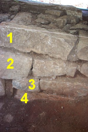
This photograph shows the surviving four courses of stacked limestone in the exterior north foundation wall (labeled 1-4). The bottom course (#4) is not completely exposed yet. This massive foundation supported the weight of two-stories of brick building AND a 70-foot-high belltower -- hence the need for such a deep foundation. While difficult to determine absolutely, our current evidence suggests that at least two (and possibly three) additional courses of stone stood on top of these originally.
Mixed amongst the rubble filling the "cellar" between the interior and exterior foundation walls, we recovered two fragments of grave markers (one is shown above). Other artifacts associated with these two fragments clearly indicate that these were tumbled into the deposit when the church was destroyed in 1863-1864. Both fragments appear to be unweathered (in other words, they were fairly freshly cut tombstones and had not been exposed for very long to the elements before they were deposited in the "cellar"). Two possible interpretations are possible for how these two fragments came to be in the rubble pile: (a) they were markers broken during manufacture for graves of soldiers who died in the "church hospital;" or (b) they were tombstones already in place in the cemetery broken during the occupation of the church -- as suggested by some of our diary and letter entries. Given the unweathered appearance of the fragments, we are leaning towards the first interpretation at this point.
AREA 3 PHOTOGRAPHS:
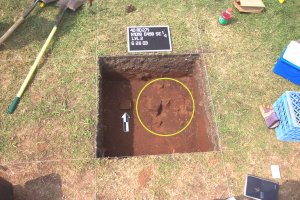
In the area marked 3 on the first photograph, a scatter of brick and limestone was identified as a "possible feature" to investigate. Although it really didn't look like much on the surface, excavation revealed a very large and deep hole with a flat bottom -- the artifacts included in it suggest that it dates to the period of construction of the church.
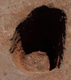
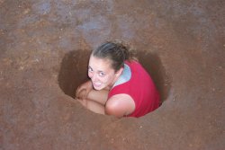
One of the crew volunteered to serve as a "scale" for the size of this feature.
Interpretation of the function of this feature will require some further investigation -- there are three-four additional scatters of brick and limestone roughly lined up along the front of the church that appear very similar on the surface. Once we investigate those, we will have a bit more information to work with on interpretation. At this point, we are working with several hypotheses that may or may not "pan out" in the longer run: (a) the feature may represent a posthole for a large scaffolding post used in the construction of the church -- in order to lay bricks two stories in height (and to construct the even higher belltower), workers would have needed to raise an extensive scaffolding around the exterior of the church; (b) the feature might represent some kind of "decorative" pillars or markers in front of the church; or (c) it might be something else entirely!
Generally, the artifacts in this feature indicate that it was probably filled back in during the construction of the church -- not during its destruction. However, interpretation will require that we examine the other similar-looking features to the west -- if we have a row of holes of similar size and equally spaced, then we will have a stronger basis for arguing that these were scaffolding posts.
We probably won't have time to answer all of these questions before the end of our "digs" on July 3 -- but we will have enough solid information to nominate the church for the National Register of Historic Places.
Our goals for our remaining week-and-a-half of labor at the site include clarifying the two north foundation walls, identifying the two southern corners, and investigating the various possible postholes and other features already exposed.
If all works as planned, we will have the front wall units cleaned up by Monday afternoon for photographs -- I'll be hauling my taller ladder in for what should be an impressive aerial!
As we begin our "next to last week" of this five-week project, I take the opportunity to recognize the students who have worked so diligently over the past three weeks -- they are a superb crew. Those of you who have followed the progress of the excavations in person or via the web pages or both will note how much they have accomplished over the past three weeks. What is perhaps not always so obvious to visitors is how much they have learned about "how to do archaeology" over the past few weeks. Our progress and success proceeds at a rapid pace because they have now become "archaeological field technicians" instead of just students. My thanks to them all -- it ain't easy doing archaeology.
The photographs of the day show our progress -- but aren't the greatest in terms of photos. At 4:00 pm in the Old City Cemetery, we have half our excavations in sun and half in shade -- not the greatest circumstances for photography of large areas. So, bear with us on the photos -- maybe the explanations will work. Maybe on Tuesday but more probably for the Wednesday report, we'll have some morning photos when the light is more even across the excavation areas.
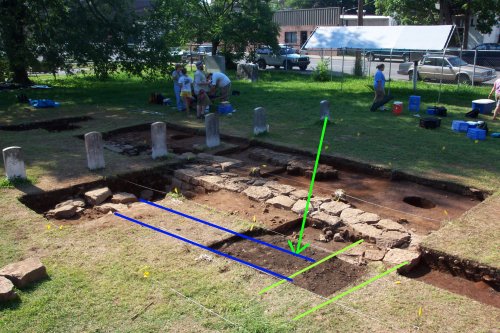
The first photo of the day shows the current excavations on the "north" foundation wall of the church -- the blue lines show the excavated portions of the foundation (dotted lines show the areas in progress or areas where the stones were missing). We now have essentially the entire 40-foot wide front wall of the church exposed.
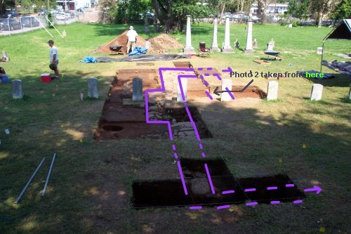
The second photo shows the double foundation wall at the front of the church (if you look at the first photo, a notation shows the angle of the shot). They yellow-green lines at the top of the photo show the outside foundation wall of the church -- the same color lines at the center of the photo show the interior foundation wall. The dotted blue line shows what we had originally interpreted as a basement or cellar for the church -- after further excavation of the excavation unit at the bottom of the photo, we now think that it is more likely a "clay pit" used to extract clay for brick production for the church. The builders of the church would have needed a large amount of clay to produce the bricks for the church -- we think they fired the bricks near the church site. Given the circular shape of this feature, we now think it was not a cellar or basement for the church, but rather a pit excavated for clay during the church construction -- upon demolition of the church, this pit that was beneath the church floor ended up being filled with debris from the church destruction.
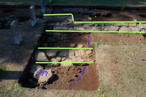
The blue question marks (???) mark some large limestone blocks -- we have left them in place for now because we aren't quite certain about them. There are two possibilities for them: (a) they are limestone blocks tumbled into the "pit" from the adjacent foundation when the church was demolished; or (b) they are limestone blocks still where they were placed by the builders for two pillars that supported the back of the belltower. If we take these cut limestone blocks out without recording them first -- we will not ever be sure if they were placed intentionally or unintentionally. I think perhaps the most important thing that many of the students learn during the field school is that we have to be VERY very careful in the digging -- we map and record lots of limestone blocks, brick clusters, and other things that turn out to be "nothing." But, for those few limestone blocks or brick clusters or "other things" than turn out to "really be something" -- it outlines the difference between the casual digger and the science of archaeology.
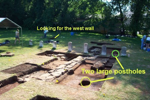
The next photo shows where we have opened a new excavation unit today. We need to determine whether that interior foundation wall extends all the way across the church -- we think it does. But, as you will note from this photo -- this 1x2 meter excavation unit will find another section of the east foundation wall (in the yellow green) and will find whether that interior foundation wall actually runs all the way (in the blue).
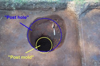
Again emphasizing the importance of careful archaeological research, we began investigating a scatter of limestone and brick in one of the excavations on the north wall -- this unimpressive little feature turned into another large posthole on the front of the church (similar to the one featured on Friday's daily journal). The next photo shows the progress on this feature -- and gives me a chance to talk about another aspect of excavation. When folks dig a hole to install a very large post or pillar, they dig a hole -- they then install the post or pillar, and then they fill the "post hole" back in around the post with dirt and other stuff. Many of you have probably done this. For archaeologists, this ends up with two parts of a feature -- a posthole and a postmold. The "posthole" is what the builders dug to place the post. The "postmold" is where the post actually sat in that hole until it was removed or rotted away. You might ask -- why do we care about the difference between a "posthole" and a "postmold"? For us - it's important. The artifacts in the posthole part reflect when the post was placed -- the artifacts in the postmold part reflect when the post was removed or rotted.
So, now we have two large posthole features to interpret -- and we have about four other POSSIBLE similar features to examine along the front of the church. The feature above is at the top of the photo -- the Friday feature is at the bottom. More to be featured later this week. Also noted in this photo is our latest excavation unit trying to confirm precisely where the west foundation of the church is located. More on that on Tuesday.
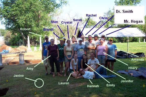
And finally, a crew photo -- these are the project staff and crew making these daily updates possible. Janine -- our student who is also an RN at the local hospital had to be at her "other job" at the time of the photo. We'll feature her on another day!
As the days pass quickly, feel free to visit us. The discoveries will continue daily!
Another solid day of work at the Old First Presbyterian Church site. Despite the fact that this was our "record warm day" of the project, the crew kept up a solid pace of investigation -- our days in the field are numbered, and we have a few more questions we would like to answer before we close up.
In yesterday's report, we featured another emerging large posthole (marked in blue in the following photo).

Yesterday, the posthole and postmold appeared like this:
Upon excavation, the posthole turned out to be an enormous flat-bottomed posthole (with crew member for scale again). The size of this feature, the incredibly dense packing of brick and limestone rubble in the hole surrounding the post, and its placement directly to the right of the main entry into the church suggests that it may represent one of the pillars supporting the belltower.
We have another feature very similar in appearance and located in the same position directly to the left of the main entry into the church -- we will probably be able to investigate that feature on Wednesday.
The crew working on the west foundation wall of the church was once again disappointed in their search for intact foundation walls -- it appears that the majority of the stone on the west wall has been removed at some point in the past. As the following photograph shows, the trench excavated to place the stones remains -- but it was once again empty of limestone blocks.
Given the types of artifacts being recovered from the deposits in the builder's trench, it appears most likely that these stones were removed at or about the time of the demolition of the church in 1863-64. However, we'll have to await complete analysis in the laboratory of the artifacts from this feature to make a final interpretation.
Given the information we now have, two crews started excavation of 2x2 meter units over where we believe the southeast corner (below left) and southwest corner (below right) should be located. Probing suggests that the southwest corner may have escaped the pillaging of limestone blocks elsewhere on the west wall -- Wednesday should tell that tale.
Investigations on the northeast corner of the church foundation continued and were completed today. As the photograph below shows, the interior foundation does continue to meet the east foundation wall.
Those of you who have been keeping up daily may recall a discovery reported on June 9 of a probable posthole for the fence surrounding the church lot -- that feature is shown in the photograph below as it appeared on June 9.
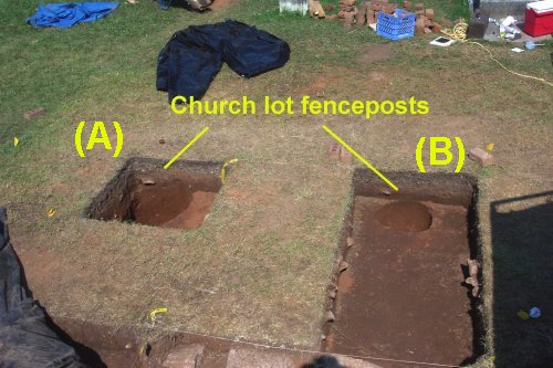
We finally got around to investigating that feature today -- that posthole is marked (B) on the following photograph. While the upper portion of the posthole was round, the postmold itself was nicely square -- suggesting a post for a nice fence surrounding the church lot. In additional investigations, we found another probable posthole (marked A in the photo) located eight feet from the first. The second posthole (A) is much larger and deeper than the first, but also nicely squared off at the bottom. Given the size and location of this posthole, we think it is probable that it was a gatepost for a gate into the Presbyterian Church graveyard to the east.
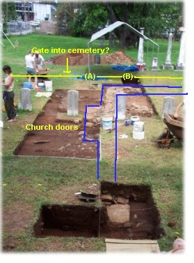
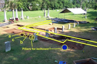
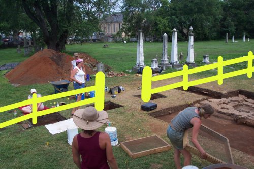
As the following edited photograph from June 17 shows, this fence would have separated the church from the cemetery -- and the large post (A) would have been in a convenient location for a gate into the cemetery. The family plots in the cemetery start immediately outside this postulated fenceline (the obelisks are visible in the background).
If time permits, we will try to confirm this hypothesis by opening some selected units to find another gatepost and another fencepost on this line in the next few days.
Three of our five crews are now working on the back two corners of the church -- both are deeply buried beneath landscaping fill that seems (from the artifacts in it) to have been placed sometime in the last forty or fifty years. Despite the heat and humidity, we managed to excavate and screen almost 110 cubic feet of soil from these two large units today. Hopefully by Thursday afternoon, we will have good news on finding those two corners.
Most of our "exciting discoveries" to report today are not particularly visually stimulating -- they are all postholes. And to be honest, they aren't super-stimulating features to find and excavate even for the archaeologist. How they look (round) or what they have in them in terms of artifacts (usually not much) is definitely NOT what makes them important -- their importance derives from what they add to our understanding of the appearance of the church and the churchyard. People rarely write detailed descriptions of fences and posts -- the documents do not tell us about where these things were or how they looked. These seemingly mundane features are exciting because they allow us to create a fuller and better picture of the church -- as people saw it in 1820.
One of the crews continued investigations on the front of the church. The photo below from June 19 shows the remnant of the brick pathway or patio feature.
 Today was one of very hard work by all of the project staff and crew -- and the hottest to date. With only a few days left in our project, we have to keep up the pace of work despite the rising heat and humidity. As is always the case, the last few days are the most exhausting and tiring as we strive to complete the project goals within our alloted time -- we have politely requested a few clouds and a nice breeze for the rest of the week! Despite the thrill of discovery, we were all more excited when 4:30 rolled around this afternoon.
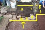
Because of two apparent (and potentially critical) postholes that extended beneath the brick pathway, we decided to remove the pathway -- after carefully drawing, recording, and photographing it. The crew removed most of the feature this afternoon -- revealing at least four likely postholes beneath it (see the photo below with labels a-d). In addition, dismantling of the brick pathway revealed that two of the brick portions used to construct the feature are much more recent that the bricks used to construct the church. As we had suspected, the pathway appears to date well after the initial construction of the church -- and probably well after the destruction of the church.
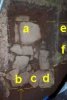
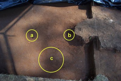
Beneath the east side of the brick pathway remnant, we discovered three probable postholes -- two small (a and b); and one large (c). The photo below shows these outlined -- they show up much better in person! While we will need to excavate these to confirm what they are, they have a solid appearance as postholes.
Perhaps more importantly, under the west side of the brick pathway remnant, we exposed another very large probable posthole (d in the photo below).
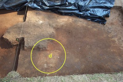
This feature is very similar in size and appearance on the surface to the postulated "pillar base" excavated yesterday (see the photo below for a reminder). In addition, it is located precisely in the corresponding spot on the east side of the main entrance to the church.
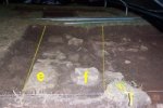
Our last crew continued work testing our hypothesis about the churchyard fence and possible "gate" leading into the Presbyterian church graveyard. The photo below from yesterday shows the two postulated fenceline posts (one being considered as a gatepost).
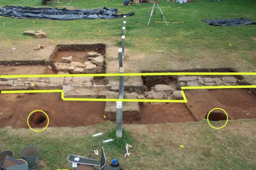
We opened another excavation unit to the north on the same line -- labeled (e) in the photograph below. The two highlighted circles show the two postholes from yesterday.
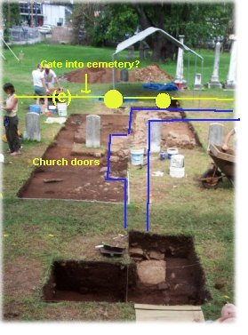
At the location marked (e) we found a another cluster of brick that appears to be a large posthole similar to the other "gatepost" feature investigated yesterday. This possible posthole is shown in the photo below.
Again, we'll need to excavate this feature to make sure it is a similarly large posthole -- but the surface indications are quite good.
To close for the day -- yes, Virginia, archaeological research is painstaking and tedious, sometimes wet and stormy, sometimes hot and steamy, and you learn more than you wanted to know about every kind of bug that lives around here. But, the rewards are when you find a new piece to the puzzle -- whether it be a foundation wall or even "just a posthole." Archaeology is often like working a jigsaw puzzle -- but you have to find the pieces first and then figure out what they mean without the box-top.
The most exciting thing for this project director/teacher has already happened with the students that comprise our crew -- they have made a critical transition over the past few weeks. They've shifted from just being interested in the artifacts found to being interested in the "big picture" of the project goals. When the questions change from "what are going to find?" to "what piece of the puzzle are we looking for?" -- we have truly become a "team" working towards common goals.
Over the past few weeks, this team has found a lot of exciting things and we'll find a few more in the next few days. Check back with us again!
An abbreviated report for tonight, as several of our excavations are "in transition" and don't have much of visual interest.
Some new "fenceline news" though -- the excavations today did confirm that the second suspected gatepost on the churchyard fenceline matches the first shown in yesterday's report.
We also opened another excavation unit to the north to see if another fencepost showed up -- by the end of the day today, we had located a promising looking posthole in that excavation unit. The "gateposts" would have permitted a five-foot gate opening. The fenceposts are 7.5 feet from the gateposts. The following edited photograph shows what we postulate the fence and gate separating the church from the cemetery would have looked like.
We also continued investigations on the front of the church with excellent results. As we reported yesterday, we were sure we had another "pillar base" similar to that on the west side of the main church doors. That proved true today in our investigations (see photo below).
We were a bit confused by how this posthole appeared on the surface when we began our investigations today. The following photograph shows in yellow the outline of the feature as it initially appeared (the somewhat mushroom-shaped outline). However, as we excavated the feature, it became quickly apparent to me that the strange shape was due to a large rodent burrow heading from the bottom of the photo into the posthole. You might not suspect that animal burrow identification was a skill required by an archaeologist -- but over the past many years of archaeology, I've learned a great deal about what animal burrows look like "in the archaeological record." My best educated interpretation based on that experience is that a wandering groundhog (or similar sized burrowing animal) was looking for a new home sometime in the past -- it started a burrow, hit all of the brick rubble in the posthole, and said "to heck with this" and headed elsewhere to dig in less annoying rubble. After cleaning out the rodent burrow, we found the well defined posthole (outlined in blue) and the postmold. We should have this posthole excavated on Friday.
And, we have some bad news and some good news on the search for the southern corners of the church. The bad news is that our two large excavation units on the back corners found no foundation walls or builders trenches. The good news, however, is that archaeologists follow the scientific method -- negative evidence provides a chance to revise our hypotheses and look elsewhere. When we found nothing in those excavation units, we took a second look at our documentary information -- it said the church was 40x60 feet. We have the forty-wide exposed on the front wall -- so we asked ourselves, why wouldn't the corners be located where we were looking sixty-feet away from the front? We think the answer was probably apparent to the folks who had seen the church and described it in writing - but not to us reading their descriptions. The question that we should have asked was "sixty-feet-long" from WHAT? We assumed from the front foundation wall and were probably wrong -- we now believe they meant from the pillar posts described above. Our initial assumption put us about six feet outside the church foundation on the south side -- we opened three excavation units this afternoon based on sixty-feet from the front posts. We already had some information to support this new interpretation from one of our excavations two weeks ago -- but we hadn't "seen" it because we weren't looking for it there. We're all convinced that this new interpretation will finally produce the southern foundation and corners on Friday (weather permitting). This is a good opportunity to highlight why archaeology is important -- we start with hypotheses and then test them. If the original hypothesis doesn't appear supported, then we re-evaluate and change the hypothesis -- and then test that new hypothesis. The south foundation and corners weren't where we our first hypothesis thought they would be -- given what we learned from moving a LOT of dirt to find nothing, we constructed a second hypothesis. We think that Friday will find our "second hypothesis" better supported! Check back to see!
Finally, since several folks have asked us about what happens when we close up our excavations this coming week... Our "backdirt pile" (the place we put our excavated/sifted soil, rocks, and brick rubble) was fairly tiny on June 3 as the photograph below shows.
Today, it has grown into three fairly massive pyramids of soil, rock, and brick (see below).
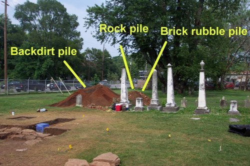
When we beginning closing up on July 2, all of this stockpiled dirt, rock, and brick will go back to cover the excavation areas -- thanks to the generosity of the Parks and Recreation Department, we will have the assistance of some city tractors to move this back to cover our excavations. None of us were looking forward to hauling those giant piles back in wheelbarrows!
The reason we will cover the excavations -- including the foundations and other features -- is that those limestone blocks are just as vulnerable to the weather as are we. Covered by the soil, the foundation is protected from the elements -- exposed on the surface, the sun, rain, freezing, and thawing will fairly quickly affect those limestone blocks.
However, don't fear that this will be the last chance to see the foundations -- our photographs, drawings, and notes will provide a lasting record of them without risking them to the elements. A final report will be produced, interpretive signs will be developed, and on-site interpretations will be prepared over the coming months.
More on Friday.
We made a lot of progress in "moving dirt" today, but our search has left more questions than answers at this point. In the search for the south foundation of the church (and the south corners), we have moved almost 230 cubic feet of dirt in the past couple of days. Unfortunately, even that volume hasn't revealed enough to give us a confident answer on where the south foundation was located.
As noted several times previously, the topsoil and rubble deposits on the south side are very thick -- about half a meter. And, the southern portion of the church has some very complex depositional history (that's "archaeologese" meaning that lots of activities since 1860 have disturbed, moved around, and complicated what is left for us to interpret back there).
In one excavation unit (see photo below), we have what might be the remnants of a builders trench and a few pieces of limstone still in place -- but it also might not be. Only a few feet away, we didn't find a similar remnant on the same line -- and on the far side on the same line, we didn't find a similar remnant either.
 Our thanks for the beautiful day for excavation today -- slightly cloudy and cool works for us!
We opened another two excavation units to see if we could hit the south foundation -- in one of those (see photo below), we did hit what appears to be limestone coursework. However, instead of running east-west as the south foundation should, it appears to be running north-south -- it might be an interior foundation wall instead of the exterior south foundation wall.
In the time we have remaining, we may not be able to answer with certainty where the south wall of the church once stood -- but we at least have the north, east, and west walls confidently defined. We'll continue our work on Monday trying to find an undisturbed section of the south wall -- but the possibility exists that we won't be able to find enough to be certain. While we will be a little disappointed if we close the project without finding the south wall, we have still learned a great deal about where the south wall isn't -- and where future researchers should look and shouldn't look if they are trying to find it. If we knew exactly where it was -- then we wouldn't need to do archaeology! And, it very clearly isn't where the documents say it should be.
On the north wall "yard area," we continued investigations -- this area includes a complex set of features. We expect this sort of complexity in the front of such a prominent building -- the front yard is an important place for "making a show."
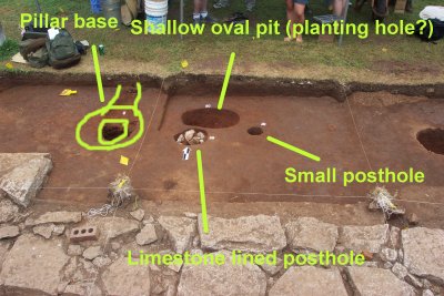
Our final interpretation of this set of features will require work in the lab and more research. However, as the photo below demonstrates, archaeology can find plenty of patterns to examine and research. Our postulated second pillar base is clearly identical to the first. Another feature is a shallow oval pit -- possibly a planting hole for a decorative shrub in front of the church. Adjacent to it are two more postholes. In later excavations today adjacent to the other "pillar base," we found a similar set of postholes -- symmetry is great in archaeology because we like patterns. The final interpretation will take a little more time and research.
So, our time in the field is drawing to a close. We leave many unanswered questions about the church -- but we have also provided a remarkable amount of well-documented information that will answer several questions. We have found more than enough to support our assertion that this archaeological site deserves listing on the National Register of Historic Places -- for archaeological sites, the critical factor is that the site can yield new information through future archaeological research. What we have discovered to date clearly demonstrates to us that the site holds the clues to answer many questions -- and what we haven't been able to find clearly demonstrates that the site holds clues to many other questions.
What I hope you will carry with you from what we have (and haven't) found is an appreciation that archaeology has some important things to contribute. Our historical documents do not record everything about the past -- there are things that are so "unimportant" that we don't record them (where fences and gates were), there are things that we "fib" a little bit about, there are things that we "dress up" a bit in our records, and there are things that we record as "truth" that are really what we "wish they were." Archaeology gives us a chance to find and touch the physical remains -- sometimes they challenge what we write down and pass to future generations.
Today was much more productive than I had anticipated in terms of "new discoveries" as we begin to close down our investigations -- despite the weather. The day opened cloudy and incredibly "muggy" -- I was already sticky at 7:30 -- it got muggier as the day went on.
However, overcast is great for photography -- our first photo of the day shows the excavations on the north wall of the church at their completion. We won't be doing any further excavation on that end during this project.
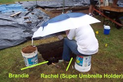
Once again, I want to compliment my students -- "The Crew" -- for how much they have learned about working as a "team" over the past several weeks. We were trying to wrap up a tremendous amount of excavation, paperwork, and recording today -- the project director (me) needed help, assistance, and tolerance throughout the day to make that work properly. We also had drizzling rain and the possible threat of thunderstorms starting about 1:30 pm -- the crew knew that we only have a few hours of worktime left. We continued working as best we could to complete excavations, drawings, and records today. As the photo below demonstrates -- one crew continued working throughout the drizzle to finish their excavation (holding an umbrella for several hours is not a fun task!). Others continued working through the drizzle elsewhere. With limited time left, we must appreciate the dedication of the students -- they know what we need to finish by July 3 and are willing to stick through uncomfortable conditions to complete our project goals.
Given the weather forecast, we may be working underneath our shelters and umbrellas to complete our work throughout the day on Tuesday.
At last report (Friday), we had several possibilities for the south foundation wall -- and I wasn't optimistic that we would find anything today that would give any certain answers. We did find more today than I thought we would -- and have some better answers (but not certain).
On Friday, we had a possible portion of the builder's trench for the south wall (see below) -- that remains a possibility, but we had some better discoveries today that may change that interpretation later.
We had a possible set of foundation stones a few feet north of that location that I thought looked good, but seemed to be a north-south wall instead of an east-west (i.e. south foundation) wall. The photo below from Friday shows that set.
In another excavation unit today -- we found what seems to be a foundation wall lined up with the above (see below). It looks very solid as a feature -- so we now have a better option for a "dotted" line in our interpretation of where the south wall was. We won't be able to test that hypothesis further during this project - but we're happy to have found some intact walls to interpret further. If the weather permits on Tuesday, I'll get some better "aerial shots" of the south wall excavation areas to try to explain the two current hypotheses.
And finally, as we begin to finish our investigations, we went back to some of our older excavation units. Some of you may recall the "iron thingies" discovered in our excavations of the church interior from June 16 (see the photo below from that date).
We completed excavation of the postholes surrounding those artifacts this afternoon -- after waiting through an hour or so of rain.
As you can see if you look carefully in the photo below, they appear to be braces for floor joists -- they have a metal plate "stand" at the bottom.
Here's a closeup of one (although not a great photo -- it started raining again!).
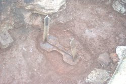
From the context, it appears that these floor braces were added after the construction of the church in 1820, but well before the demolition of the church in 1864. Our current (but darn tentative) interpretation is that these features are probably in the part of the church where the extensive and weighty pulpit once stood. The floor perhaps began to sag from the weight of this feature -- and they had to go in and put in some braces for the joists to stop that from happening (many of you may have seen similar types of props in older houses). We'll do some further research, but I suspect that this interpretation will hold true.
For tonight, I shall close down my narrative -- we have a lot of work to finish on Tuesday. I'm hoping that we will have some good weather for at least most of the day to finish out our work.
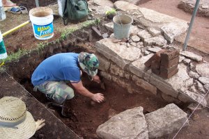
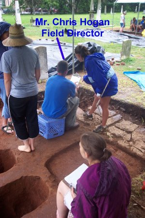
I also take this opportunity to acknowledge and thank the most important member of my staff -- Mr. Chris Hogan, the project Field Director. For the "learning experience," he volunteered to take on a very difficult task as my assistant on the project. The crew members have put in a solid 40-hours-per-week from 8:00-4:30. Chris and I started work weeks before the class started -- inventorying equipment and supplies, purchasing needed items, hauling equipment, and getting ready. Our workdays start about 7:00 am -- hauling all of our equipment to the site each day and home in our trucks each evening -- and end by 5:00 or 5:30 or 6:00. Running errands in the morning, during the lunch hour, and after 4:30 was another common task -- and meetings on Sunday to plan for the coming week. That sixty-plus hours per week on his part to keep the project moving and working smoothly is responsible in no small for the "grand results" you can examine throughout the web pages. As the photograph below demonstrates, Chris is usually working while I'm wandering around taking photographs and lounging in my hammock -- if you look carefully through the photographs in the web pages, you will often find him in the background of those photos working to keep the project moving along. Chris -- thanks for the great work. Finally, if any of you electronic readers are archaeologists looking to hire a hard-working, fast-learning, and generally darn good field tech -- I suggest you watch for applications from a Mr. Chris Hogan.
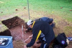 As anticipated, the day started off drizzly -- and stayed that way for much of the day. From beneath shelters and umbrellas or just sittin' in the drizzle, we completed the remainder of our final records today. The photograph to the right shows two of the students at work on measurements and drawings. What is perhaps not obvious in the photo is the rain dripping from the tent shelters onto the soggy crew members! As we prepared to backfill our excavations, making sure that we had recorded everything necessary with drawings, measurements, and photographs was critical. I once again compliment the crew on their very hard work today under very uncomfortable conditions.
On to discoveries... We actually had another interesting discovery today -- despite the fact that we were working on closing down our excavations. As some of you may recall, we were investigating several probable fenceline posts on the east side of the churchlot. I had even postulated our fenceline and gates in the photo below from June 26. Note the large blue arrow pointing to an excavation that we completed and recorded today.
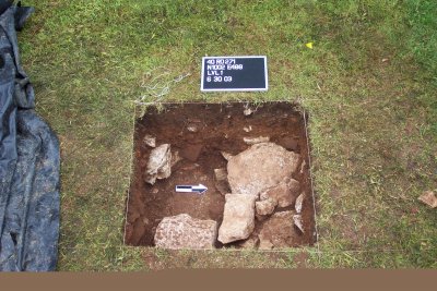
As we completed that excavation, we discovered something intriguing -- and with great promise for future investigations at the site. As the photo below shows -- the deposits in that excavation unit extend over four feet below the current ground level. The upper zone of the excavation is a gravel pathway or drive that we think was installed sometime between 1960 and 1980. Below that was a level of fairly sterile clay (by sterile, archaeologists mean "culturally sterile" in the sense that the zone doesn't contain many artifacts. The intriguing discovery below that was a dense and thick layer of brick rubble -- we think that this probably relates to the construction of the church. The brick fragments in the fill do not have mortar or plaster associated with them -- there are few nails and not much window glass. So, rather than being a deposit of rubble from the church destruction, we think this might relate to the church construction instead.
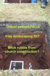
Unfortunately, we don't have time to further investigate what this deeply buried zone means -- but we can provide a couple of good hypotheses for future investigations. We have some evidence from our investigations that the front yard of the church originally sloped down substantially towards Vine Street -- the old Vine Street may have been two or three feet below where the current pavement sits. Alternatively, this small and deep excavation unit may have intruded into the middle of a trash disposal pit dug during the construction of the church to get rid of brick fragments and other waste. Analysis of the artifacts from the excavation may give us a few more clues about which of these hypotheses might be correct -- but probably some future excavations would be required to really come up with a firm answer.
Finally, thanks to some very very very hard work by the crew in the afternoon after the rain stopped -- we got all of our excavation units closed up. While we are looking forward to the assistance of the Parks & Recreation Department with a couple of tractors with front-end loaders to do the final topping off of our excavations on Wednesday, we moved a gigantic amount of stone, brick rubble, and sifted earth today to ensure that the church features are protected from tractor tires and the elements.
As the photo below illustrates, most of our excavation units were filled with brick and stone rubble from the bottom up to about 20 centimeters below the surface -- the upper level will be filled with sifted earth to facilitate regeneration of the grass. All of our excavations were lined at the bottom with plastic -- so that future investigators of the site will not have any problems finding where we have already excavated.
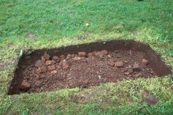
The larger-scale view below shows how much of our excavation area looked as we closed up today. The front foundation wall of the church is now covered with plastic and enough sifted earth to protect it -- we'll complete filling the area with mechanical assistance on Wednesday. The excavation square in the foreground is the one discussed above that contains the deeply buried questions for the future.
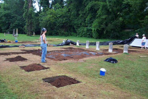
As I close for the evening, please be assured that there are 20 of us sharing two things: (a) soaked, tired, and stressed muscles and backs; and (b) a great sense of accomplishment that it was worth the effort to help add a bit to our knowledge of early Murfreesboro, Rutherford County, and Tennessee.
We'll be at the site tomorrow to finish wrapping things up -- a little bit later than usual at 9:15. And we will hopefully have a chance to leave a bit earlier than usual. Our thanks to all of our interested visitors over the past several weeks. Our final "daily report" for the field part of the project will probably be tomorrow -- the reports from the laboratory analysis will start in a week or two. So please keep checking back!
A lovely day to close out the field portion of our work at the First Presbyterian Church site. With some relief and with some sadness, we returned the approximately 1045 cubic feet of carefully screened dirt, brick rubble, and limestone to the excavation units.
When we arrived at the site on June 2, the church lot appeared as in the following photo.
Yesterday, we left the site "ready" for some assistance from the City Parks & Recreation department in moving our enormous pile of dirt (see below).
When we departed today, we left the area as it appears below -- the grass will quickly spread into the nicely sifted dirt. If necessary, this fall, we will come back and seed the areas with grass to complete the restoration to its former appearance.
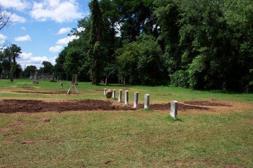
As the "field" part of our project concludes, the staff and crew leave you with another crew photo -- tired and dirty, but satisfied with the success of our endeavor.
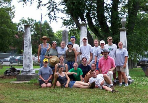
Now the "lab" part of our project starts -- processing the artifacts recovered from the site (washing, sorting, cataloguing, and analyzing) will take about two months. Additional historical and architectural research will continue at the same time. Recording and mapping of the surviving tombstones in the cemetery will continue. By early-mid fall, we will begin preparing the paperwork for nomination of the church and cemetery to the National Register of Historic Places.
Although the fieldwork and the daily updates to the webpage end today, the project itself will continue for several more months -- and the webpage will be updated as we have new things to add.
We hope you've enjoyed tracking our progress -- and will continue to do so as the project continues.